
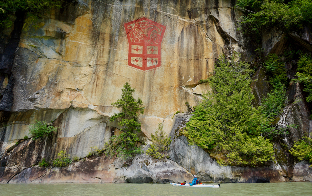
A stunning display of art and culture greet you at the head of Kingcome Inlet.
This is part two of a 24-day kayaking honeymoon expedition on BC’s South Coast from Quadra Island to Kingcome Inlet and back again.

Trip route in blue – linking previous trips we have done in green (Discovery Islands), red (Central Coast & Cape Scott), and yellow (Broughtons).

Detail of route for Part 2 of the trip (route in blue).
Part 2: Tribune Channel to Pott’s Lagoon (via Kingcome and North Broughton): 8 paddling days. 2 rest days. 240km.
While the first part of the trip had taken us through new areas, the second part of the trip would be like returning home. L and I have fond memories of our first multi-day kayak trip ever in the Broughtons in the spring of 2017. We also completed several trips paddling around the area while living in Port McNeill in the winter of 2021.
We planned to explore one of the last unlogged watersheds on the BC Coast in Bond Sound; revisit the cliffs and waterfalls of Watson Cove; enjoy the beaches of Burdwood; reach the head of Kingcome; and check out the waters of North Broughton Island. In 2017 we paddled to Moore Bay, intent on paddling Kingcome Inlet but were too intimidated by remoteness, length, and lack of campsites, and turned back the following day. Paddling Kingcome became our main objective for this trip.
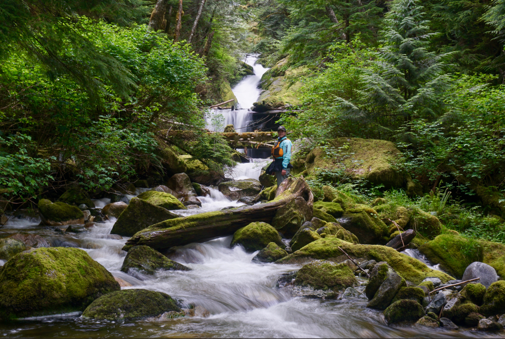
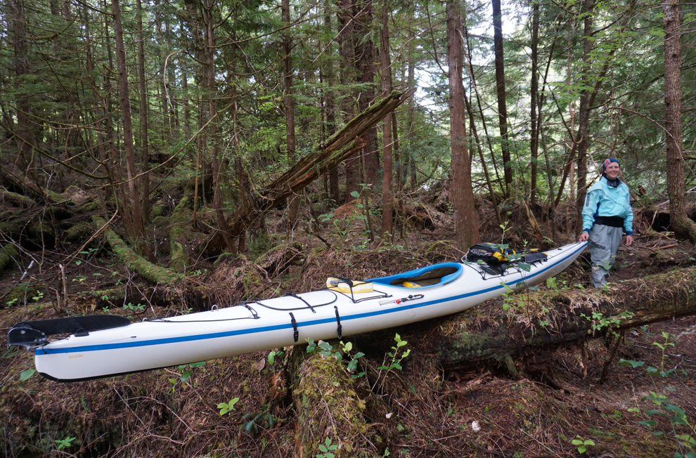
Day 9: June 03 – to Tribune North Campsite
We woke to a low ceiling of cloud and grey skies. The forecast called for clear skies, and after a few years of living on the coast, L and I thought we recognized the pattern and decided to trust the forecast.
We had planned for an attempt at Mount Read, the high point of Gilford Island. Over the past couple of years we have had some luck bagging big coastal peaks from the kayaks, but more often than not, the combination of weather, fatigue, food supplies, and looming return to work dates have made adding a peak bagging mission to a kayak trip challenging – there is little time to sit and wait for clouds to clear and motivation is often lacking by the time you’re a few days in!
We continued paddling to the log dump where we had mapped out a route to the summit. We were discouraged by a continuously dropping ceiling and steady rain. It was early though, so we decided to paddle the 3km our beach for the night, set camp, eat, and paddle back if the clouds started to lift. We left the dump, set camp and took a rare swim.
At noon the clouds lifted in sync as they seem to on the coast. We were a few hours behind where we would have been if we had been faithful to the radio. Always trust the forecast.

Cruising up the old logging road system on Mount Read.
After bungling around for a few hours on logging roads and barely reaching snow, we concluded our route, which still involved a fair amount of bush whacking to access, looked too steep without ice axes and our earlier decision to see what unfolded with the weather had delayed us a few hours. It was now late in the afternoon and if we made the summit we would be descending and paddling back in the dark. We left Read for another time.
L photographed the usual piles of shit and mayhem left behind by Interfor. Boxes filled with plastic from seedling trees for replanting and heaps of rusted metal debris. Another great example of “sustainable” forestry practices on the BC Coast and the appalling accountability of the logging sector and regulation of the industry. On that note, Tribune Channel offered some of the worst examples of logging practices we have seen on the BC Coast. I expect Toba soon too will sport as many landslides.

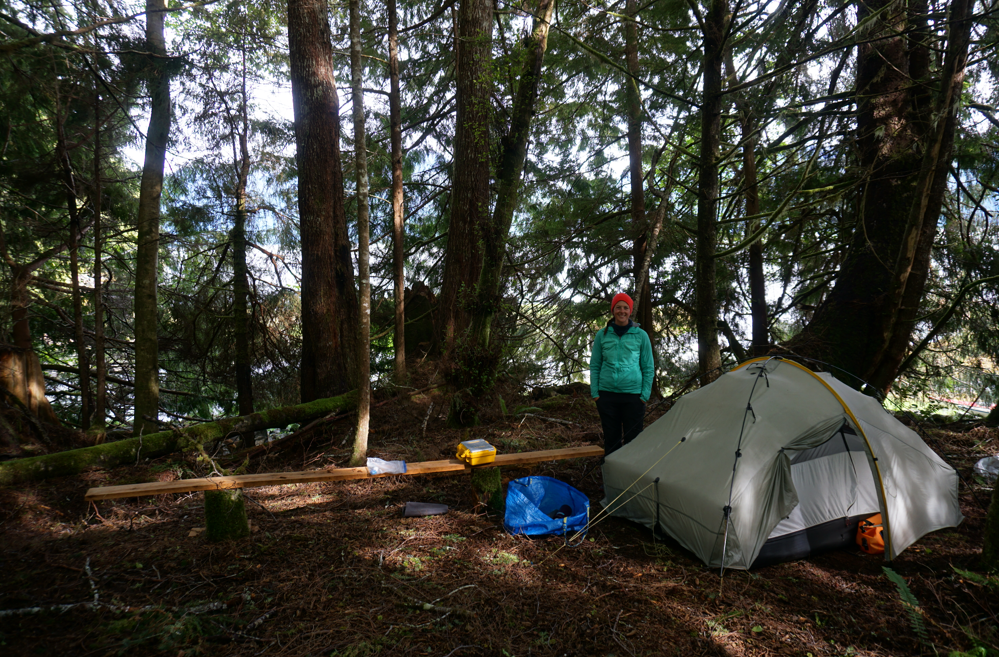
Nice views from the campsites in Tribune.
We returned to camp slightly disappointed and wandered off on our own for a bit. I checked out the creek and L cooked up our 9th pasta of the trip and we sat and watched the prawn boats cruising past.
Day 10: June 04 – to Burdwood via Bond Sound
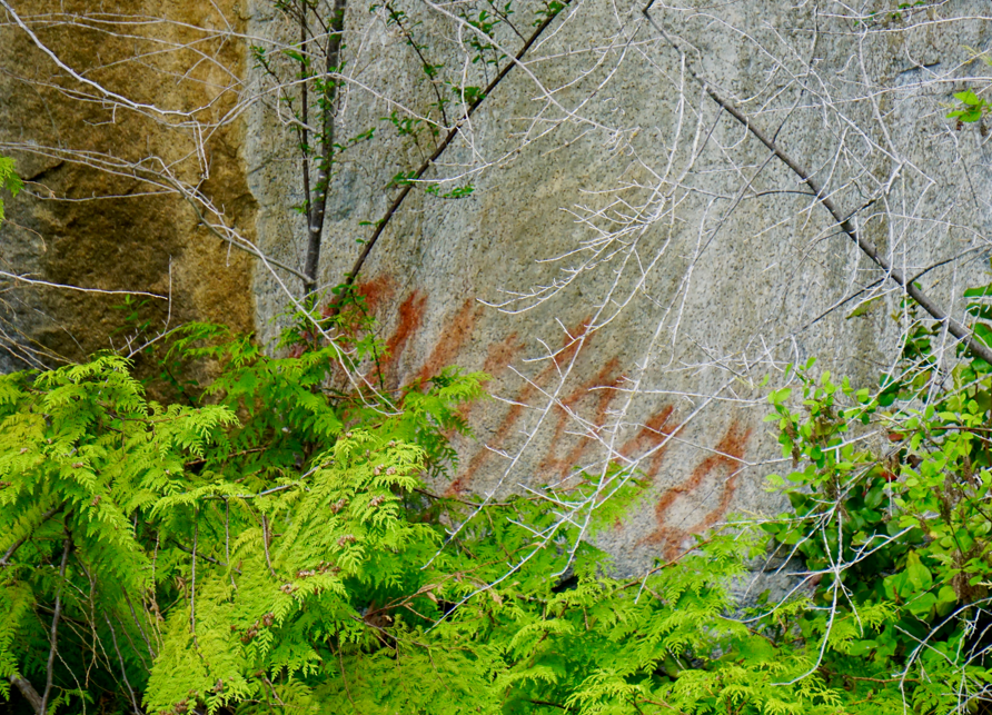
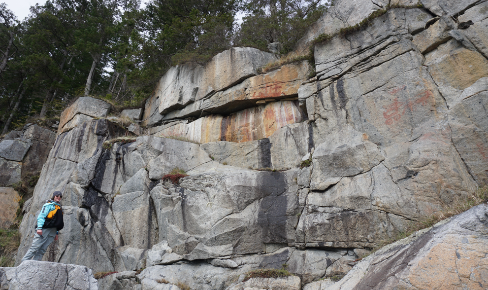
The next morning we awoke to the first whale of the trip – a humpback just offshore. We were on the water shortly after, though not for long! An incredible panel of pictographs awaited just around the corner.

The first whale of the trip cruised by on the morning of the tenth day as we broke camp.

A vivid and stunning pictograph panel only 100m from the Tribune North campsite – a great way to start the morning.
After crossing Tribune Channel we entered Bond Sound, a long awaited destination. Paddling the eastern shore, we passed mature forest and cascading creeks. Bond Sound has minimal logging activity. The local First Nation has begun construction on what we believe to be a cultural retreat center. We exchanged hellos and paddled a short distance up the Ahta River, drifting back in the current before turning around.
A beautiful creek flows through mature forest into Bond Sound.

The estuary at the head of Bond Sound – prime grizzly habitat, but none were around today.
We briefly stopped in the estuary before continuing on – our destination – Watson Cove! As we left Bond Sound a stiff wind picked up and we played in the rebound waves. The cliffs at the mouth of Bond Sound are particularly impressive landmarks. Soon we came across multiple pictographs.
A pictograph near Watson Cove.
As we crossed Kwatsi Bay, we connected our previous trip from 2017 with other trips to form a route to Vancouver. Kwatsi is another magical place that we chose to skip on this trip due to time.
The shoreline around Watson Cove is some of my favourite on the coast, and though we had visited in 2017, we had actually not stopped at one of it’s most remarkable highlights. We had since heard about this special spot from multiple people, and were eager to visit. L spotted a small piece of flagging tape, easily missed, near a sloping granite ramp. We pulled up the boats and followed a muddy trail to this magnificent giant! It’s pretty crazy to think of a tree of this magnitude thriving on a tiny peninsula!

Billy’s Tree – Watson Cove. Breathtaking.
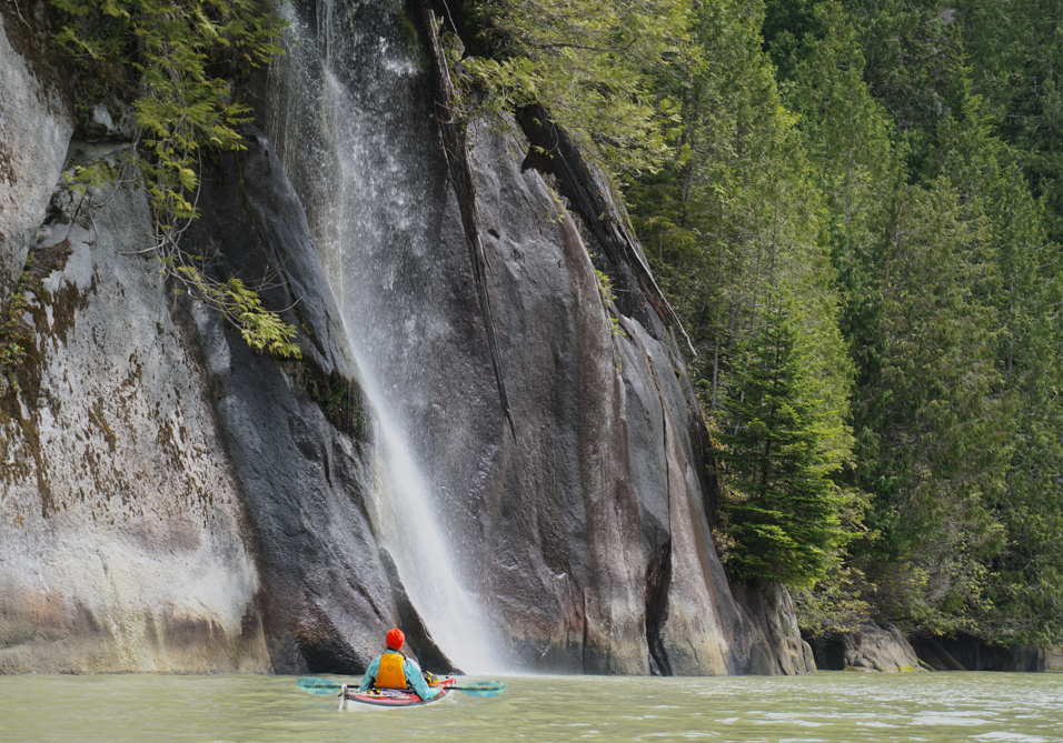
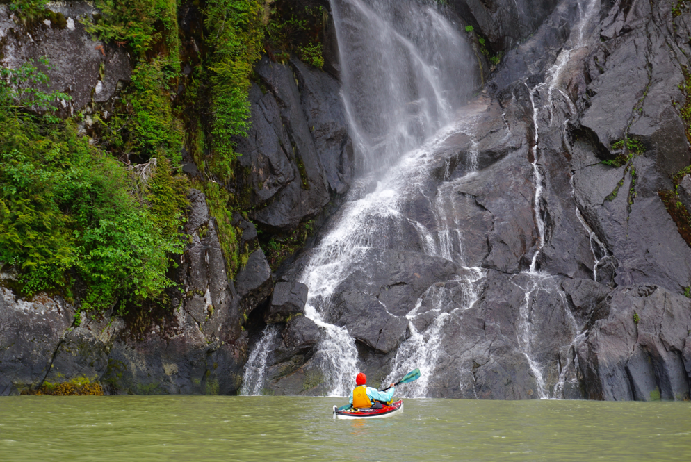
After Watson Cove, we paddled past Lacey Falls. Another repeat visit, but this time, without a fish farm! Lacey is a truly special falls and it is awesome to watch the water flowing in sheets off the bedrock. Easy access – go check it out!
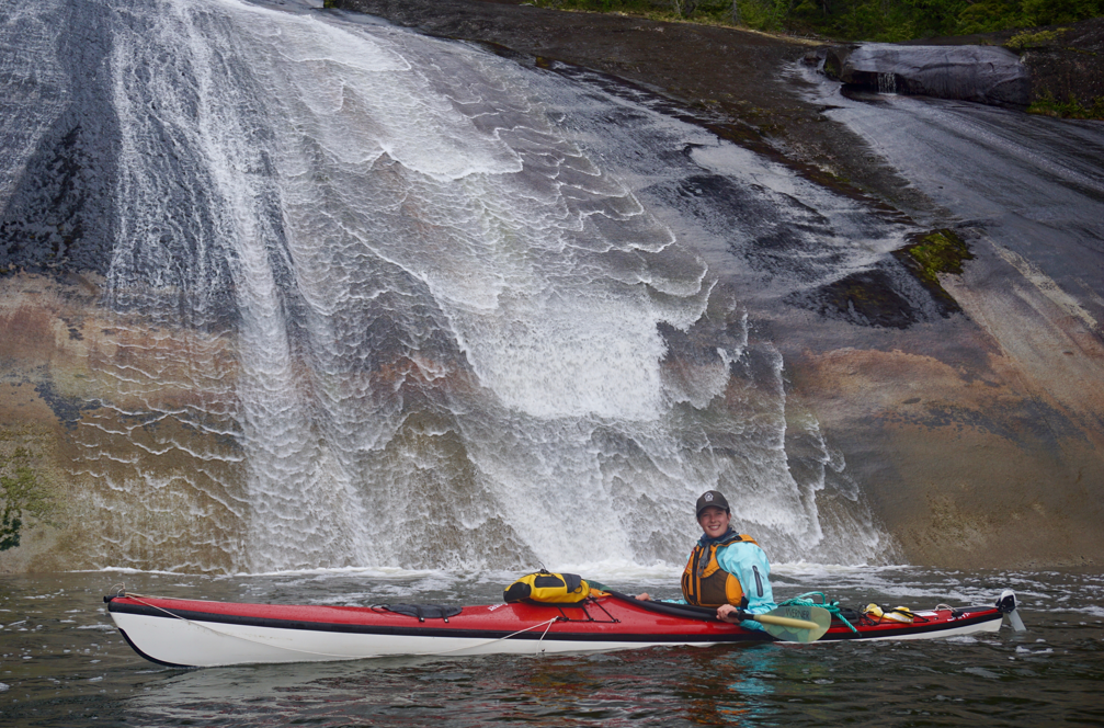
Lacey Falls. It was great to see this place four years later and without a fish farm.
The final highlight of one of our best days of paddling was reaching the Burdwood. This group of islands offers some of the most spectacular midden beaches and granite shoreline in the area and is apparently a favourite site among locals, kayakers, and yachters alike – make sure you go in the off season if you want it to yourself!
We pitched our tent in a familiar spot and laid out our picnic blanket for another fantastic pasta dinner.

L relaxing in the Burdwood group after an amazing day of paddling.
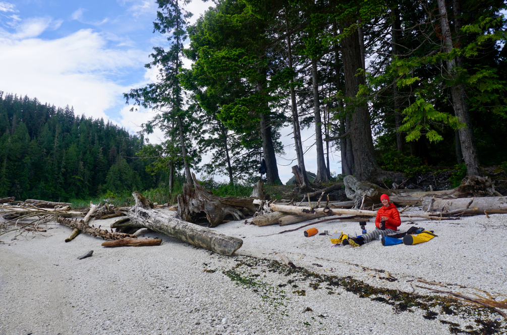
Day 11: June 05 – Rest Day on Burdwood
The wind howled throughout the night and we slept in late, making pancakes and reading on the beach despite a drizzle that seemed to follow us around. The rain was light enough that eventually the wind dried everything.
Waiting for the orca to show up while taking a rest day at Burdwood. Could someone name a more beautiful midden beach, please?
By early afternoon a familiar sound startled us out of our daze as a pod of orca cruised past. They playfully swam along the far shoreline then stopped for an hour or so and played together in the kelp beds just offshore from the beach.

Orca playing near Burdwood.
A great day to choose to rest and a great whale experience! Although L was used to seeing orca from our time in Hyde Creek, these were the first orca she had seen on a kayaking trip. We relaxed away the rest of the day and drifted into an easy sleep and dreams of granite walls, powerful waterfalls, and ancient cultures.
Day 12: June 06 – to Holden Creek
After a restorative day on Burdwood, we were prepared for the few longer days that we had planned coming up. We left Burdwood aiming for Deep Sea Bluff and the entrance to Simoon Sound. Ever since reading the Wild Coast books, I had wanted to check out the site at Simoon Sound that John Kimantas recommends. Unfortunately we found it in disrepair – driftwood covered most of the small beach and the upland was completely overgrown. We noted what we could and continued on.
I had really wanted to check out Simoon Sound as well, but quite honestly wasn’t prepared to bother with the paddle out – it didn’t look that interesting and there were sizeable clearcuts that marred the beauty of the landscape. We had also paddled from Burdwood to Moore Bay (and back) on a previous trip and didn’t feel the need to repeat the journey.
We lazily paddled the Sound, refining our version of 20 questions, and aimed for the far NW tip of the inlet. As far as sea kayak portages go, this was an easy one. There is even a faint trail connecting the water bodies. We needed a few trips to ferry gear over, but we were easily done within the hour with our boats and spirits in tact. Consider this route if you want to mix up your paddle into Kingcome!
Verse from our ‘trip song’:
“8K into Simoon Sound,
By land or sea we were Moore Bay bound,
Didn’t want to paddle back out again,
So we picked up the boats and we carried them,
Through the forest then across a lake,
Man, that portage worked out great!”
The “trail” along the portage route.
We cut across Moore Bay and turned around the corner that had stopped us four years previous. The water was glassy and calm and we crossed the mouth of Kingcome in brilliant sunlight. The area feels incredibly remote.
Corsan Peak is one of the most prominent peaks along the BC Coast and absolutely dominates the skyline. Unfortunately the area is currently seeing intensive active logging.
We crossed to Philadelphia Point and easily found the panel of pictographs high on the cliff. Similar to many of the pictographs found on the BC coast, this one was painted after first contact with Europeans. The shoreline was bluffy and unsuitable for landing – a theme which would continue into the inlet and is common in most of BC’s fjords. We paddled the remaining 1 km to Holden Creek, where we hoped to find suitable camping.
Despite a tricky landing at low tide amongst rockweed cover boulders, we found easy camping in a large cleared and flat forest site. Holden Creek provided abundant fresh water and a gorgeous waterfall to photograph. We pitched our tent without the tarp and relaxed with our kindles and some ice-cold water in the sun at the edge of the forest.
Surprised to find cleared and level ground at Holden Creek.
It was a perfect afternoon, and this ended up being one of our favourite sites. Be warned however, while a great spot, it does require some tenacity and extreme care if approach or departure is timed for a low tide. We dubbed the landing an “ankle-breaking beach” and unloading and loading took longer than usual.

Enjoying a perfect afternoon in the wilderness of BC.
Day 13: June 07 – to Moore Bay (via Kingcome)
What a spectacular day! The scenery Kingcome Inlet offers is unparalleled, though the paddle in and out in one day is a commitment, particularly given the limited camping.
From Holden Creek we paddled past granite cliffs, multiple waterfalls and pictographs, enjoying views of snow covered peaks in the near distance. We explored the ruins of Charles Creek, marveling at how much had changed since the heyday of the little community once perched on the side of a mountainous wall with numerous waterfalls.

The first of many pictographs for the day, but one of only a few modern day pictographs along the entire coast.
Just past Charles Creek a small memorial cross can be seen above gentle granite bridging the trees and the ocean. It reminds me of a similar site on East Redonda Island, near Connie Point.
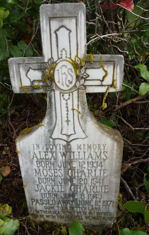
A memorial site on the north shore of Kingcome we were lucky to stumble upon.
To truly appreciate the natural and cultural beauty of Kingcome, one must paddle the entire distance of the inlet (note that we did not enter the estuary or continue towards the community of Kingcome out of respect for the request of the First Nation during COVID-19).
Typical stunning shoreline paddling up Kingcome Inlet.
Near the end, the inlet makes a sharp turn north. Here you will find a floating service dock used by the community. This dock was being rebuilt, and we stopped for a nice, but brief chat. Some sources indicate this dock is unused, in disrepair, and could be used for camping. This is not the case – a beautiful asset to the community with signage indicating visitors were not welcome due to COVID-19, I suspect camping, except in the case of an emergency, would be disruptive and disrespectful.

This pictograph at the head of Kingcome Inlet depicts the sale of coppers for cattle in the early 20th century. Note the faint ship on the left side. As with many of the pictographs in the area, it has been defaced – this one by drilling; luckily the damage to this stunning art was minimal.
Several remarkable pictograph panels can be found in this area. Two Wolves at the Dawn of Time by Judith Williams is an excellent resource to consult for further information.
Modern day rock art at the head of Kingcome Inlet. The artist is Marianne Nicolson.
Crossing to the southern shore of the inlet we made slow progress, enjoying each waterfall we passed, though eventually the novelty wore off as day turned to evening.
More waterfalls along the Kingcome shoreline.
After a brief stop to visit the pictographs at the entrance to Moore Bay, we finally reached the familiar Forest Rec Site dock, which had deteriorated a surprising amount from our previous visit in 2017. The tent sites and picnic table were in great shape though, a welcome “easy” set up (minus hauling gear from the dock at low tide!). We were delighted to see a friend’s name in the log book from just a few months before.
I think a guidebook mentions the dock is not much use to kayaks as it is too high and too small…We made it work!
We were exhausted, but our time in Kingcome is a memorable highlight of the trip!
Day 14: June 08 – to Watson Island
We woke up tired. We thought we would have a nice short day, get some food at Sullivan Bay, and camp nearby. Camping in the area is limited though and we were uncertain of where we would spend the night.
We watched a humpback lunge feeding from the dock at Moore Bay and then headed towards the north side of Gregory Island. We crossed to the mainland shoreline where we found some pictographs amongst the wildflowers. This shoreline was quite nice and varied with bluffs and mature forest. Signs warned us to stay offshore due to blasting: they would have been helpful later in our journey.
The wind was building to more than 20kn and we crossed back to the North Broughton side. The shoreline here was beautiful and we enjoyed a leisurely paddle to Sullivan Bay. We hopped out of the kayaks with hopes of a beer and maybe even a burger! Unfortunately, aside from a caretaker, the community was abandoned – most of the owners are American and were not allowed in to Canada due to COVID. We managed to buy 10 chocolate bars, some chips, and a coke that only ended up hurting my teeth.

The empty community of Sullivan Bay.
We paddled to Atkinson Island and then Kinnaird Island. We weren’t having any luck finding camping, so we checked out a rumour that there was camping at the Surgeon Islands. After a thorough exploration we concluded that there definitely is: if you are a sadist.
We left disappointed and in the reels of a sugar crash from our first soda in months. Aside from roughing it and tempting fate with the high tides, all that was left was an established BCMTN site to the north on Watson Island. We paddled back to Kinnaird and then grumbled the last 6 km of the way to Watson Island, checking every beach en route until finally concluding we were going to Watson.
The beach at the NW tip of Watson Island provided an easy landing and we found plenty of camping a short walk up from the shore. The old building remnants were interesting to check out as well. The history is fascinating here.
Pasta number fourteen went down well and we enjoyed some of our fresh Sullivan Bay chocolate sitting on the rock outcrop beside the beach. Despite being tired on the paddle, we were happy to have come this far north. We elected not to visit Mackenzie Sound, where we were quite sure the folks at Nimmo Bay would let us use their trails to climb Mount Stephens (one of the first peaks named on the Coast by Vancouver), but at this point we didn’t have the time (or much motivation for the hike!). We’ll save that fun trip for another day.
Day 15: June 09 – to Cullen Harbour
We loosely followed the eastern shoreline of Grappler Sound past Stuart Narrows, without making any stops. It was windy and we were once again unsure of our destination for camp so we wanted to make some distance early in the day.
Unfortunately the wind would be in our face much of the day, and the combination of pervasive sea star wasting disease and multiple large and loud fish farms was not particularly inspiring. We did see a group of five kayakers travelling Wells Passage heading north east, but did not pass closely enough to communicate.
We took a small passage east of Dickson Island, which offered welcome shelter from the wind and really enjoyable paddling among small islands.
The shoreline of Queen Charlotte Strait is incredibly beautiful and one of our favourite places to paddle. We have been fortunate to paddle this area multiple times when waters are like glass, and we were treated to this same luxury once again.
Glassy waters along the south shore of North Broughton Island.
Reaching Cullen Harbour we decided it was time to call it a day. The guidebook had noted several excellent rock ledge camp spots, and we began a thorough search that had us questioning by the end if “relatively flat” was included in the criteria for a great spot…
As it started to rain we hastily chose a tiny patch of clamshell, wondering if it would hold with the tide. We had a difficult unload and set up our tarp. L fell asleep, and when she awoke from her nap she found the tidal rapids raging – we had inadvertently landed on this tiny spit of clamshell during slack tide at the entrance to Booker Lagoon!

Entrance to Booker Lagoon postage stamp campsite – not really recommended, but a highlight site of the trip!
We didn’t get wet that night, though it was one of those times where we were organized with an alarm set just in case. It was a charming site that involved some “type 2″ fun, but we remember it fondly!
Day 16: June 10 – to Turnour Island
We departed early to align best with what we estimated as the slack at Booker Lagoon. However, this meant that the tide was low. This was the most difficult boat loading of the trip and by the time we got into the boats, the rapids had built and we got shot out of the entrance.
We crossed Fife Sound to the islets on the west side of Eden Island. We heard and then smelled the welcoming committee to the Broughton Marine Park long before we saw them. We drifted by at a safe distance, drank some tea and enjoyed the many sights and sounds of this large Steller sea lion colony. Always a blast! Curious young sea lions came to say hello. What another great start to a day!

A welcoming committee back to the south Broughtons.
From here our route was comprised of passages not paddled on previous trips as we wound our way through the archipelago. We rounded the west side of Bonwick Island and cruised through the Sedge Islands – some very fine paddling. Beautiful and countless tiny islets with abundant marine life and healthy kelp forests.
We took a familiar route past Midsummer Island to Village Island. This area is another favourite that we have visited many times, so we did not linger this time. On previous trips we had stopped on the island with permission of the First Nation and marveled at the big house poles and a fallen totem nearly reclaimed by the forest. Just past Village Island we saw a tiny fawn swimming between islets.
We were eager to check out a campsite we hadn’t yet visited that was highly recommended by a friend, but it didn’t materialize as easily as expected – the Turnour campsite is on the point north of Mink Point.

Taking advantage of the sun at Turnour Island.
We pulled up and spread our gear out to dry in the sun. As we were relaxing, Jen, a solo kayaker from Whistler, emerged from the trees, having accessed the site from the other side of the point. She paddled around and joined us, sharing the site, a wonderful dinner, and good stories for the evening.
Day 17: June 11 – to Pott’s Lagoon
We were in no rush today as we only had a short distance to travel. Of all the days on the trip, this would be the one to take a rest day – the forecast for JS was SE40+. But we wanted to rest the next day at our friend’s float house in Pott’s Lagoon. We figured it was only 10km as the crow flies…too bad it was in a SE direction down Beware Passage!
We optimistically said our goodbye’s to Jen, who prudently opted for a rest day, and paddled out to the channel. We were smacked in the face with a blast of wind. But the waves were still small, the boats were sitting low, and we were able to muscle through the wind and tuck ourselves close to the shoreline. We followed Turnour most of the way until we were able to cross to the shore of Harbledown to make the crossing to Klaoitsis Island easier. Luckily we had spent considerable time this past winter exploring the magnificent site of Karlukwees, so felt no need to battle the wind longer than necessary.
The rock art at Karlukwees is some of the most remarkable on the south coast. This is from a previous trip circumnavigating Harbledown Island.
We crossed Clio Channel in strong winds and aimed for the midden on Klaoitsis. What a gorgeous island and area in general. Though we were challenged by the wind we greatly enjoyed the scenery and history of the area.
We followed the shoreline until we were across from the entrance to Pott’s Lagoon. The wind followed us all the way to the cabin – the outdoor shower didn’t do us well without a shower curtain and wind gusting to 30kn – at least we gave the anchored boats a good show.
We helped ourselves to some Dark Matter and turned up the heat. We were toasty and dry within a few hours and settled in to read more Raincoast Chronicles. Later that day L paddled out to buy some prawns from a local boat and returned with two crabs. The night was shaping up well!

Luxury in Pott’s Lagoon.
Day 18: June 12 – Rest Day at Pott’s Lagoon
A day to do nothing. We woke late and indulged ourselves early. The left over crab got mixed with rice to make crab cakes, the fire got turned on, and I finished reading Billy’s book for the umpteenth time. L read some of the cabin’s literature on Big Foot.
We were well rested and looking forward to promising forecast for the last part of our trip. We had the perfect amount of time left to explore before we needed to return to work. Up next was the famed Robson Bight, the currents of Johnstone Strait, dinner at Blind Channel, and a route less travelled back to Quadra.

So amazing. Thanks for sharing.
LikeLike