
First Half: Days 1 – 3
During one of the wettest June’s in recent memory, Dan and I tried to plan two separate week-long trips into the mountains. The first – exploring the area around Pinecone Lake – we pulled the plug due to the miserable forecast. The second trip we decided to keep on the books despite the unsettled weather, and we managed to sneak into Slim Creek and climb twelve peaks over eight days and nearly 100km of off trail travel.
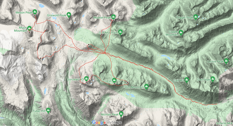
Slim Creek is located in the southern portion of the relatively new Southern Chilcotin Mountains Provincial Park just north of Gold Bridge in SW BC. Dan and I were banking on the drier climate of the Chilcotins and rain-shadow of the massive peaks to our west to provide a few days of sun, despite the forecast.
Stats & Route Map
Participants: Daniel & Anthony
Dates: June 27 – July 4, 2020 (8 days)
Total Distance: 94 km (GPS)
Total Ascent: 5,050m (GPS)
Peaks: 12
Day One: June 27, 2020 – Slim Creek Bushwhacking
Distance: 16km
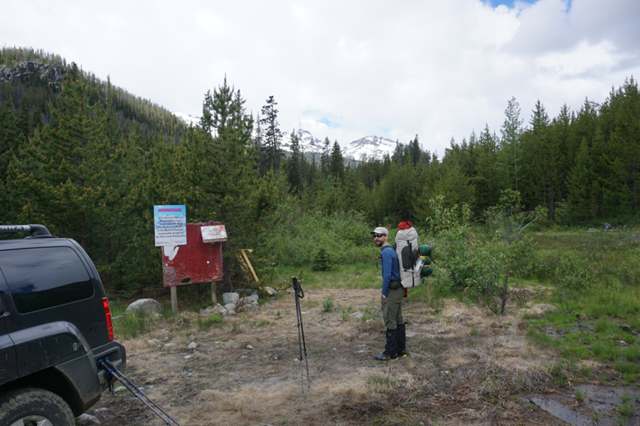
We left Whistler at the relatively luxurious time of 630 and made good time over the Hurley to Gold Bridge, finding the turn off for the FSR with ease. Road access is marvelous at the moment (Summer 2020), and we were able to drive the entirety of the Slim Creek FSR to the “Trailhead” at 1600m; a few kilometers past the bridge over Slim Creek.
Neither of us did much research before the trip, but we were aware that we would be in for a long day of hiking through brush and swamps. We left the truck around 1030 after strapping the final pieces of gear on to our matching Hyperlite bags. The bags were feeling awfully heavy for a summer trip – but we had packed an extra three-person tent for the bad weather days, so we couldn’t complain.
We made good time on a great trail running along Slim Creek, before hitting the nearly 2 km marshy area below the creek draining “Leckie Pass”. We saw the only other people of the trip in the first hour and a half, encountering three guys finishing a traverse from the Jewel Bridge Trailhead, and going past Gun Mountain. We managed to jump over both streams of the creek, tossing the backpacks across.
After the creek, the trail begins to deteriorate. It seems a lot of people head up to the alpine of Leckie Lake, following the drainage. Our route lay ahead though, to the headwaters of Slim Creek. We continued up the valley, seeing the odd bit of flagging, but the route was obvious.

The weather had been predicting rain all day, but we would not see any precipitation till the evening, and it would all fall as hail and light snow. Travel was fairly easy, through open terrain as we climbed the low-angle valley, finally reaching the pass at around 530PM. The last hour had been a lazy one – stopping for some food and a break just a kilometer from camp.
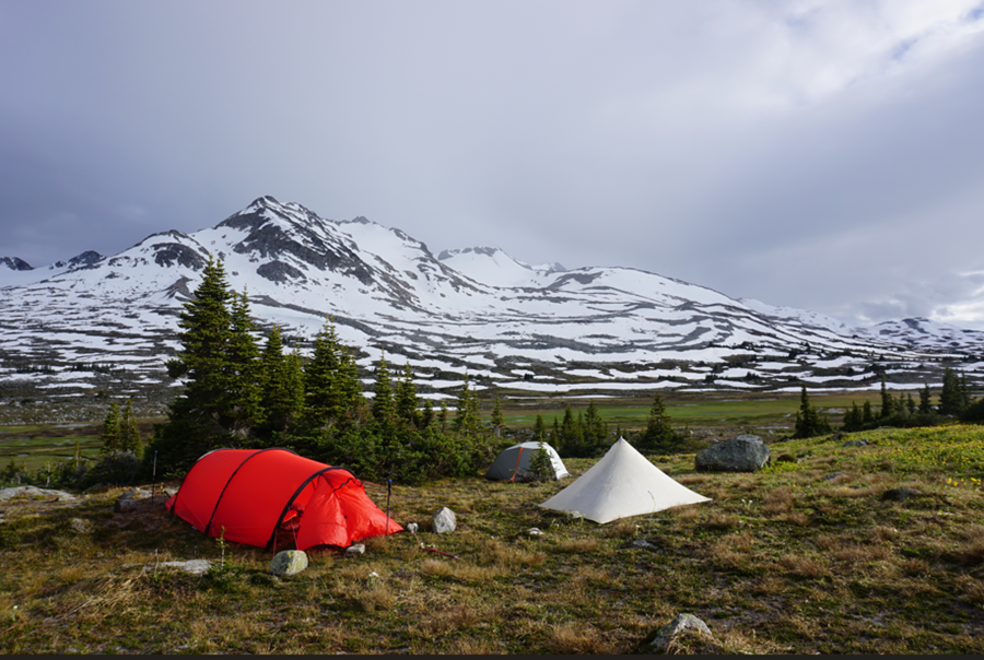
Camp was set at 1,950m on the north side of Slim Creek below the pass separating Mount Steve from the Gun Peaks. Our three tents were pitched in a stunning location overlooking the Sorcerer Group and complete with fresh running water, large flat eating rocks, abundant firewood, and a safe place to hang the food.
We each had a solo tent and then a large three-person tent as a dinner tent. We made a hasty dinner, gazed in awe at the amazing terrain around us, hung 30 lbs of food, and promptly fell asleep.
Day Two: June 28, 2020 – A Short & Windy Day
Distance: 5km
Summits: Mount Steve
The following morning, we didn’t bother setting the alarm and slept late, waking to unsettled weather. We lazed around camp, putting the final touches on our home for the next seven days. We had both had a lazy spring and we were tired from the day before. By mid-morning we decided that despite the lousy weather, we should at least head up the closest bump to camp.
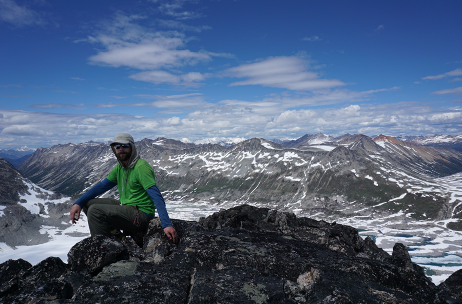
Mount Steve is a lowly bump that should have never been named; it was just a few kilometers to the NW of camp. It was an easy hike of only about 350m and we only expected it to take an hour each way. It was blustery and we were feeling particularly lazy though, so we settled on this as our sole objective of the day.
We left camp in the late morning and rambled our way up towards Mount Steve. It was incredibly windy, but the rain held off for the most part. Near the summit, despite the clouds, we got great views towards Griswold Pass and the Subatomic Glacier (where we would head the following day), the Sorcerer Group, and the Gun and Musket area. We were excited for the next couple of days of exploring.

We lingered for a bit, playing in the strong wind before taking a different route down and dropping off the south ‘face’ of Steve. We stopped for a bit in some sub-alpine trees to eat some food and reignite our stoke. After this short break, we traversed due east and back to camp. It had been a long and difficult day and we were ready for some rest!

I retired to my tent for a bit and did some reading and napping before Dan and I met up in the big red tent to make dinner, drinks, and play cards. We had a fire after dinner and checked the weather on the inReach. It was looking like tomorrow was going to be the only clear day of the trip, was expected, and we decided on a big day to climb the peaks around the Subatomic Glacier.

Day Three: June 29, 2020 – A Visit to the Subatomic Glacier
Distance: 32km
Summits: Lepton S2 (Mount Higgs), Lepton Mountain, Baryon Peak, Muon Mountain, Meson Peak
Today was forecast to be the only clear day of our entire trip and we intended to take advantage of it. We were both up early and packed and ready for a long day. We fired up some water for breakfast, coffee, and tea and then took off.

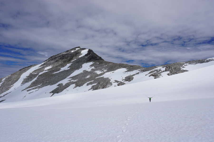
Our plan was to head towards Griswold Pass and the Subatomic Glacier and to bag as many peaks as possible. We finally had views of the entire pass, and the Sorcerer Group looked stunning in the early morning light. We headed west from camp, bypassing Mount Steve and heading towards Lepton Peak. Once past Steve, we dropped slightly through beautiful heather meadows and small streams.

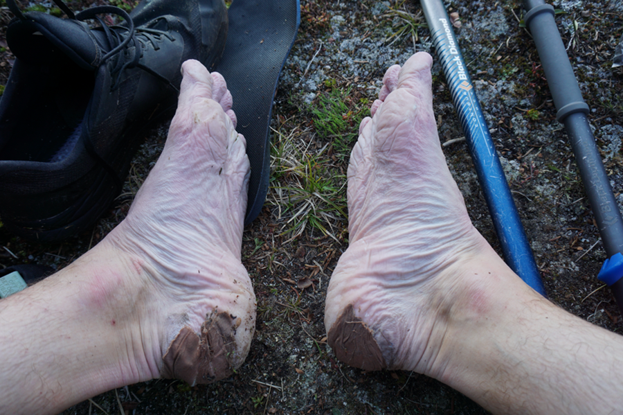
We took a short break on the sandy meadows in the broad valley that drains Griswold Pass to the south. Here we had to take off our boots so we could ford a creek that we could not find an easier way across. The water was cold, but it was a nice break for the feet.

After the refreshing crossing, we chose an easy route up the broad eastern flank of Lepton S2. Despite its lowly name, it was prominent from camp and looked like it had great views of the Subatomic Group. We only had about 600m to gain and it was all quite straightforward, but near the summit a steep step with some snow had to be negotiated.
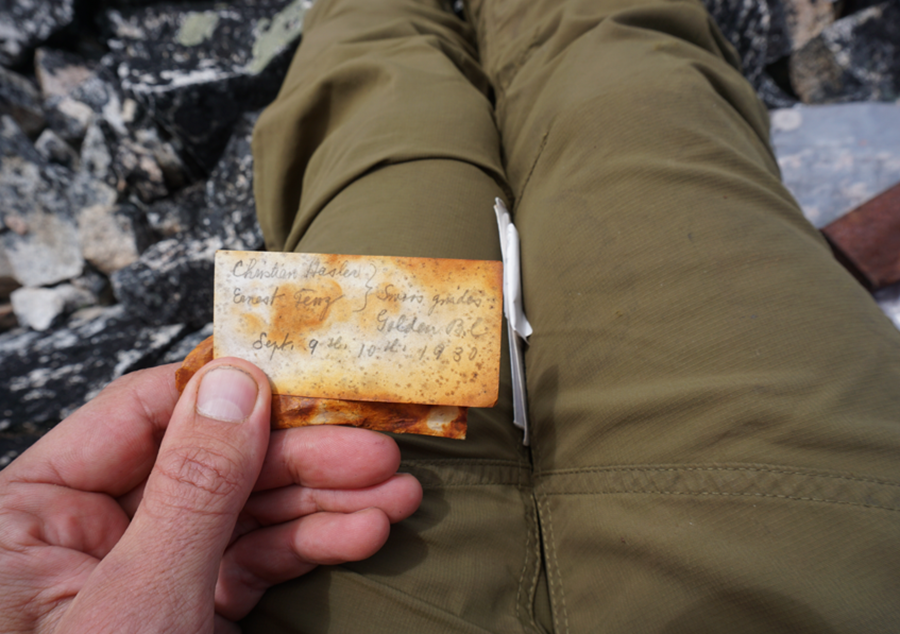
The summit of Lepton S2 held a cairn and a summit register. The views from here were amazing and only a taste of what the other subatomic peaks held. There were numerous entries in the peak register – many from the 2000s. However, there was an entry from 1930! By far the oldest I have found.

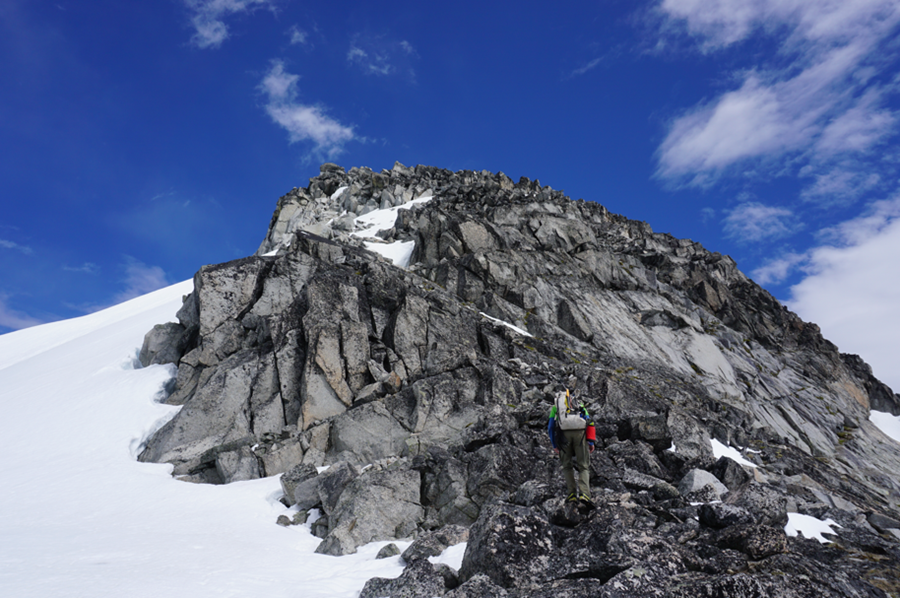
We put everything back in its place and then continued north towards the other peaks. We had to drop a bit, but the elevation loss was minimal and the route was straightforward. The south ridge of Lepton Peak is mostly just a hike on talus, but the last 50m provided some scrambling opportunities and we took advantage. The views from the summit were equally brilliant here.

We took in some food and water, but did not linger on the summit and dropped down steep snow to the base of Baryon Peak. We had a long, steep glissade that helped speed up our pace and cool us off. Baryon was similar in nature to Lepton – it was largely a hike, but the summit offered some fun scrambling. We took a bit of a longer break on the summit here, soaking in the views.
Back at the Lepton-Baryon col, we had a decision to make. We were tired, and if we turned back now we would already have had a big day out with some peaks in the bag. But Muon Mountain and Meson Peak were very close and the day was still early! I managed to convince Dan to cross the glacier and bag the final two peaks!
The crossing was simple over flat glacial terrain, and we were able to move quickly without crampons. We crossed the glacier to the north side of Muon Mountain and climbed steep snow to the NW ridge. This was my first time on steep snow since an accident the year before and I felt very unstable.
The final 50m of the ridge was another fun scramble to our fourth summit of the day.
We took a different route down, finding continuous snow down the north face that we could glissade almost back to the base. Tired, but stoked at our progress, we walked over to the south side of Meson Peak. An easy hike and scramble brought us to our final summit of the day.
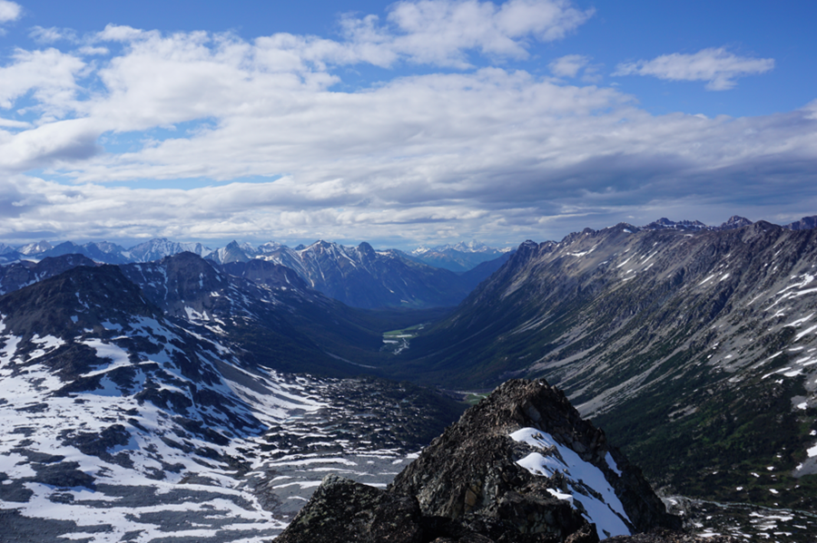
We also saved the best views for last. Meson Peak offers a perfect view down the valley that drains Griswold Pass to the NW, as well as a view over the Subatomic Glacier and the countless peaks of the Coast Mountains. The late afternoon light made the setting surreal.
We were feeling tired now and we dropped quickly off Meson Peak and crossed the toe of the glacier to Griswold Pass. It had been our intent to camp here on Day One, but I liked our current campsite. If I were to do it again though I would camp somewhere between the two sites – perhaps in the valley to the south of Griswold Pass.

Anyway, we stumbled over meadows and spring snow through Griswold Pass and back to the base of Mount Steve. The light was gorgeous and the flowers and beauty of the area took away from our sore feet. I needed some food so I left Dan behind and rushed back to camp, where I fired up the stove and took off my boots to give my feet a much needed breather.

Dan got back and we relaxed in our eating area and had some great food and hot drinks before enjoying a well-deserved sleep. The next few days were scheduled to be stormy and were we psyched to spend a few days resting.
To read the second half click here.

One thought on “Slim Creek Headwaters Basecamp (First Half)”