A three day loop of Hornby and Denman Islands testing out our 1983 Nautiraid skin-on-frame tandem sea-kayak for a longer planned trip.

Map showing the route we paddled around Hornby and Denman Islands. Mount Geoffrey – the highpoint of Hornby Island – is the blue icon.
A Loop of Hornby & Denman Islands. 60.5 km. 3 days.
L and I had recently acquired a skin-on-frame Nautiraid tandem kayak built in 1983 and we were planning on paddling for three weeks in the Bahamas later in the year. We had not paddled for the entire summer, instead spending time in the mountains, and were keen to test out the boat before flying a few thousand kilometers with it!
We had never paddled the area around Hornby and Denman Islands and thought the sheltered waters would provide the perfect testing ground for the new boat. We were also hoping to take advantage of the off-season and have some easy options for camping, which can be very difficult during the summer on these islands. L had never explored Helliwell Park, so that was on the list, as well as a hike to the top of Hornby Island to Mount Geoffrey.
Day 1: November 10, 2018 – Deep Bay to Tribune Bay
We left our place in Kitsilano early and managed to catch the first ferry from Horseshoe Bay. We made the drive to Deep Bay across from Denman Island quickly and we were ready to launch by mid-morning. L had never been to either island and I had only been a few times during summer in high school. We were both stoked to explore the islands and try out the new boat.

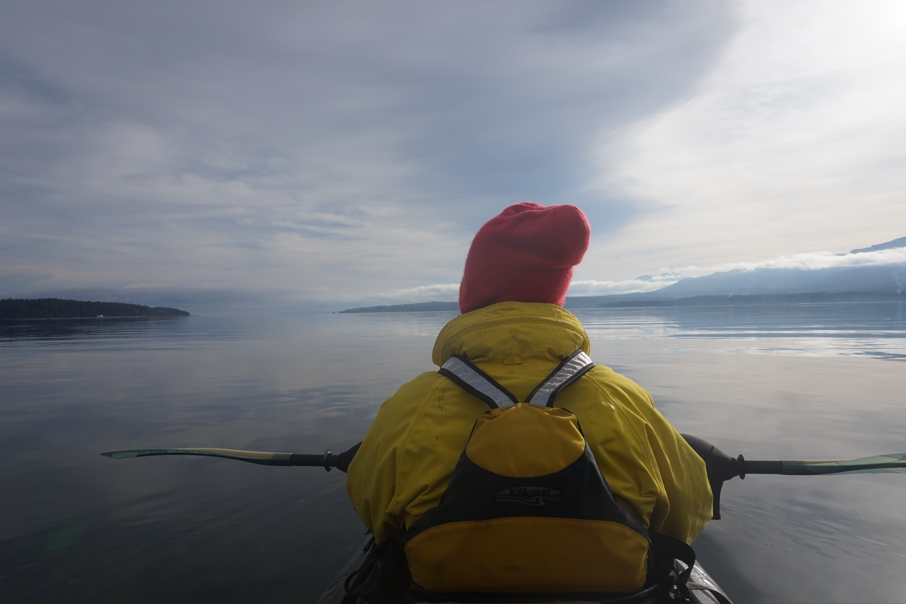
First time using the Nautiraid! Yep, that’s a tandem boat!
We were the only ones using the boat ramp that day and we were thankful for the extra room as we navigated how to load the kayak properly. It was our first time loading the boat and it was not as roomy as what we were used to. This would also be the first time we paddled a tandem kayak together. Since the kayak is skin-on-frame, it has no built in internal flotation. It also has a very limited skirt system, so we were grateful for the calm conditions.
We squeezed in all the regular gear and set off for Denman Island. It was awkward having to match up our strokes perfectly and conditions were quite cramped in the boat. If you have ever paddled a skin-on-frame boat, you know it is not the most comfortable experience – combine that with a 14′ double! We crossed directly to Boyle Point on the Denman shoreline. At Boyle Point, the wind remained calm and we were getting into a better rhythm of paddling. We decided to cross directly to Norman Point and head straight for Tribune Bay, our intended stop for the night.

Landing the boat in Tribune Bay.
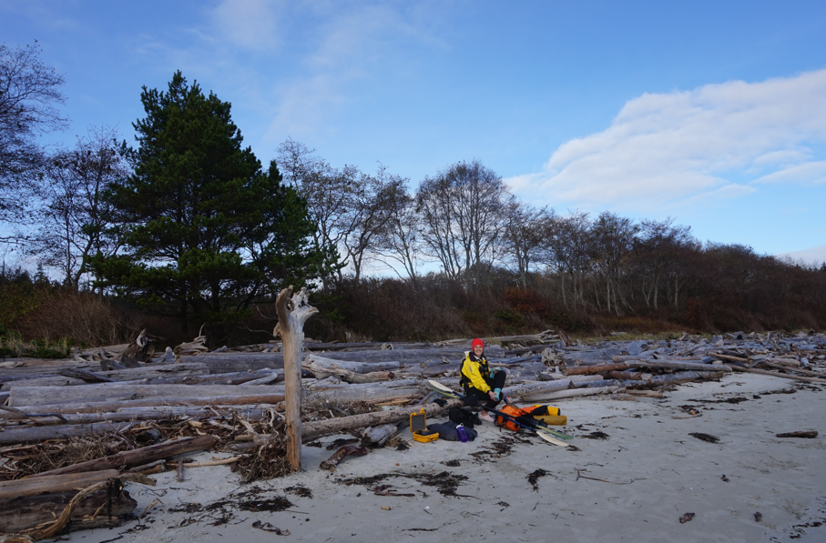
Tribune Bay all to ourselves – it often pays to do things in the off season, even if it means you will be cold!
We only ended up paddling about 15km for the day, but the boat is very wide and travelled at a much slower pace – despite being a tandem. We pulled into an almost entirely deserted beach at Tribune Bay – there were a few families on the beach, but very quickly we had it all to ourselves. We hauled our gear up to the driftwood at the top of the beach and threw on some dry clothes. We were hoping to hike to Mount Geoffrey, which is the top of the island and needed to hustle if we wanted to do it in the daylight.
We left out our stuff on the beach and followed roads until we reached the Mount Geoffrey Regional Nature Park where some fine trails led us to the summit. There are some great views from up here, but the cloud cover was still quite low and it was getting late, so we did not linger. There are numerous options for trails and we took an alternate route down. By the time we reached the road again it was very dark and needed headlights for the rest of the way back to the beach.
When we returned to the beach, we cooked up some much needed dinner and the clouds lifted just enough to provide a spectacular sunset. It was another great night in the tent, camping on the coast.

Pleasant trails leading up Mount Geoffrey.

Illicit camping in Tribune Bay – it doesn’t get much better!
Day 2: November 11, 2018 – Tribune Bay to Jáji7em and Kw’ulh Marine Park [a.k.a. Sandy Island Marine Park]
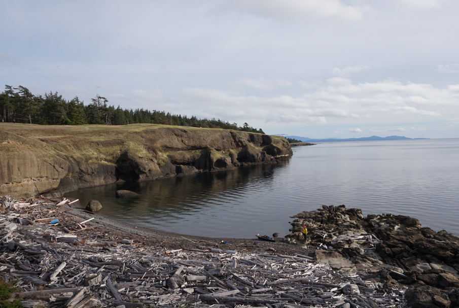
We woke to an empty beach and a gorgeous sunrise over the Strait of Georgia. Another relatively short day awaited us on the water and we were hoping to spend some time exploring the trails of Helliwell Provincial Park. The shoreline of Hornby Island is dominated by the same geology present in the southern Gulf Islands, and is fascinating to paddle past.
The day was warm and numerous Steller’s sea lions were hauled out on boulders, enjoying the heat. We enjoyed the short cruise out of Tribune Bay and pulled in to another beach after only a short time on the water.
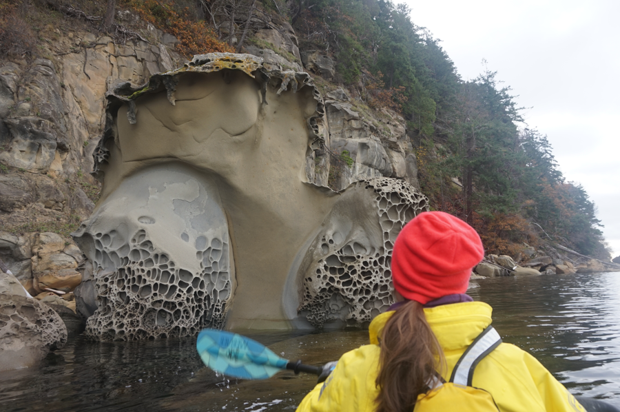
Typical geology along the Hornby Island shoreline.
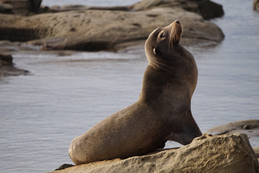
California sea lion posing hard!
I think the beaches near St. Johns Point on the eastern tip of the island would work well to access the park, but we were unsure of the best stop and Mushroom Beach looked easy and appealing. We hauled the boat onto the beach and then set out to explore the park. The access from the beach is a bit steep, but a rope has been installed to help you up (and down). We spent a few hours strolling around the park and enjoying the incredibly special Garry oak and douglas-fir ecosystem. This is the most endangered ecosystem in BC, which supports numerous endemic species. Aside from the obvious, new research from 2021 shows that one of the many threats to this ecosystem is invasion by Scotch Broom, which is one of the most common invasive plants on Vancouver Island. Make sure you clean your camping equipment!!
Helliwell was a gorgeous stop but we slowly made our way back to Mushroom Beach to get back on the water. We had a quick snack and then shoved off, not too keen on the incredibly flat, windless, 10km crossing that we were facing to Denman Island.
Exploring Helliwell Provincial Park.
The gorgeous wilderness of Mushroom Beach and Helliwell Park.
The shoreline around St. Johns Point, past Whaling Station Bay, and towards Shields Point was incredibly scenic and varied and we saw much marine life. The views across the Strait were great despite the increasing cloud cover. We made quick(ish) work of the bluffy shoreline and then decided to cross directly from Shields on an angle to Longbeak Point at the northern tip of Denman Island. This ended up being a crossing of slightly more than 10km and took quite a bit of time in the wide, short boat. The wind remained calm though and we chattered the crossing away, reaching the far shore as the light was getting dim.
We continued a little ways into the shallows of Jáji7em and Kw’ulh Marine Park (Sandy Island). We had to line the boat as it got much too shallow to paddle, but eventually we were able to pull up on a stunning, deserted, sandy beach. We hadn’t done too much planning for the trip and were still not certain where we would camp, and we were unsure of the regulations in the marine park. It was late and dark though and we were cold, so we pitched the tent on the beach and enjoyed our second night of guerilla camping.

Exploring the trails of Jáji7em and Kw’ulh Marine Park.
Day 3: November 12, 2018 – Jáji7em and Kw’ulh Marine Park to Deep Bay
We woke to a very cold morning and one of the most stunning sunrises we have seen on the coast. We were in no rush, so we packed up leisurely and loaded up the boat. The views were short lived though as the sky began to cloud over, but the mist and clouds created their own beauty. We crossed Henry Bay and cruised along the Denman Island shoreline until we reached Denman Point. The shoreline was unremarkable and we did not see any wildlife.
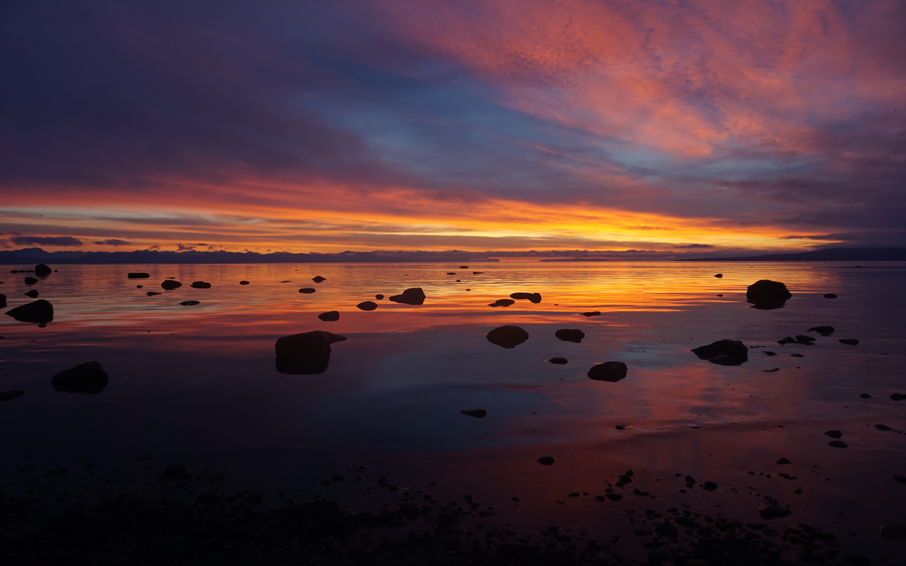
An absolutely stunning sunrise over the Coast Mountains from camp.
From Denman Point, we crossed Baynes Sound to Buckley Bay, lining up our crossing to avoid the Denman Island ferry. We continued along the Vancouver Island shore and then did a long crossing of Mud Bay. The day remained grey and the wind calm. Baynes Sound and Mud Bay were uneventful and we were quickly back at our truck in Deep Bay.
This was a great trip in the off-season to a very popular area and we enjoyed the rare solitude. The unique geology of the islands makes the shoreline fascinating to paddle; while the views across the Strait are gorgeous; there are parks and trails to explore; and the wildlife is fantastic! It was also a very successful test of our tandem skin-on-frame kayak that we were planning on using in just over a month.
A long, dull paddle back to Deep Bay, down Baynes Sound. An anti-climactic ending to another great trip!
