
Note: This trip traverses through Homalco, Klahoose, and Sliammon territory. Be respectful of cultural sites and practice leave-no-trace camping anywhere you camp!
Although she is an avid kayaker and had spent a week living on Read Island in 2019, it was a very wet week, and Lindsay had yet to do any paddling in the Discovery Islands region. While three days would have been nice to do a loop of Maurelle and end at Evans Bay on the south side of Read, we only had two days, and elected to do a Maurelle circumnavigation starting and ending at Surge Narrows Community Dock.
This is a world-class kayaking itinerary despite being only two days long. It encompasses Surge Narrows Marine Park, Octopus Islands Marine Park, Hole-in-the-Wall tidal rapids, the tremendous mountains of the Bute area and amazing wildlife; as well as fascinating First Nations sites; and a visit to the largest known tree in the Discovery Islands region. To complete the same loop from Quadra, one could easily leave from Discovery Islands Lodge or Herriot Bay and include Read Island and the Rendezvous and Penn Islands.
Day One: Surge Dock to Francisco Island via Octopus Islands
The first day was designed to be a relaxing one, giving us time to explore Surge Narrows at a low-tide slack and then cruise around the Octopus Islands. Lindsay also needed a few hours in the afternoon to dedicate to reading for school. We left the Surge Community dock around 8AM to be nice and early for a 9AM low slack. [Tip: If you are ever planning a trip to this area, I highly recommend aligning it with large tides and low slack tides – the intertidal marine life is astounding].
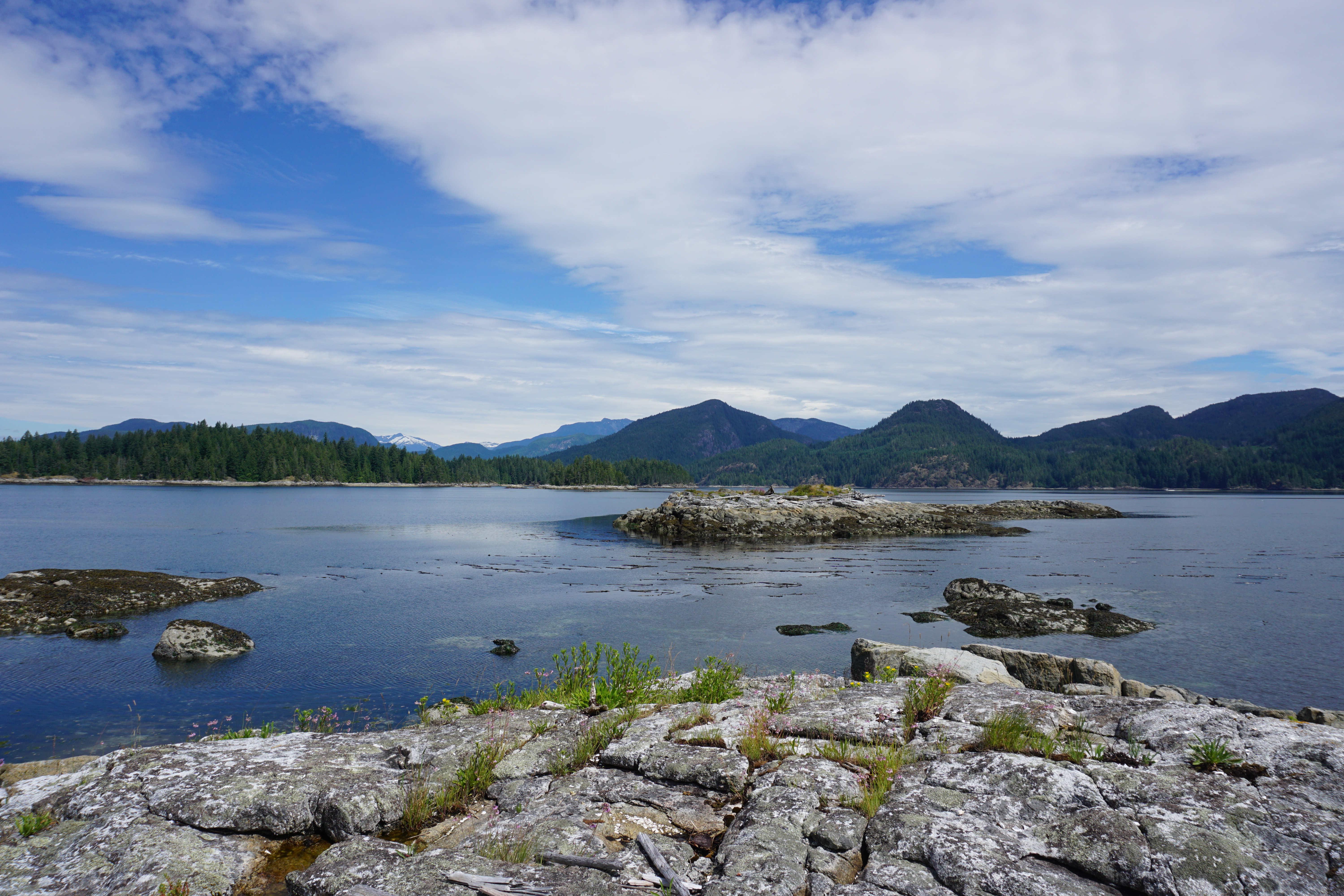
The ebb sucked us into to Goepel Passage on the northern end of Surge Narrows, where the current is diminished. That’s where the fun began! It is always hard taking people through Surge that have never been, as the intertidal only gets better, but there is a definite time limit. Today though, we manage to spend nearly an hour exploring in the park.

Everything in Surge is supersized, from the barnacles (the size of our hands) to the red urchins (largest in the world) to the gumboot chitons and even the limpets. It is often like paddling through an aquarium. We stopped and admired the massive colonies of green urchins eating everything in their path, and the insane mats of aggregate pink-tipped anemones. The ochre stars and garlic-smelling leather stars have also made a great comeback from the sea-star wasting disease. With the very low tide we glimpsed black katy chitons covering the rocks, doing their best to avoid sun-light hitting the light receptors on their backs. Before leaving the park, we crossed over to the Maurelle shoreline, scattering some harbour seals off their rock perch and gliding through flocks of pigeon guillemont and Bonaparte gulls before we reached a First Nations pictograph tucked under a gnarled douglas-fir tree.

The Sliammon people have been living on these waters for more than 15000 years, and pictographs, middens, and clam gardens lay evidence of a long history of occupation.
Lindsay and I crossed over to the Quadra shoreline and continued in a building wind and threatening clouds. A small squall blew through and we had cold, stinging rain and a slight headwind. We pulled into Yeatman Bay and Lindsay threw on a jacket to keep warm. I decided to brave out the rain in the hopes that it would stop soon. Yeatman Bay is the site of much current archeological work on the island and is a seasonal village site of the Sliammon people.

We left Yeatman and continued NW towards Octopus Islands. Elephant Mountain on the opposite shore of Maurelle Island is aptly named, as we can see the elephant standing in profile as we paddle. We stopped for a quick bite and to take a look around on “Mink Island”. Mink Islands are the two islands connected at low tide outside of the park and anchorage on the eastern entrance to Wyatt Bay.
After visiting Mink, we crossed to the cabin – a must on any Octopus Islands trip. The cabin is an old summer home that has been transformed into the Driftwood Museum, where boaters can leave sign of their passing with wooden signs and artwork.


We ate lunch on the balcony of the cabin, and then left to cruise through the marine park, catching the rising tide through the intertidal gap between the largest of the two islands. Our loaded kayaks barely cleared the seafloor where thousands of sand dollars crawled under our boats as we drifted staring into the crystal clear water.
From here we made a quick crossing to Francisco Island where we will spend the night. It was early and I suggested to Lindsay a ten-minute loop of the island. I have only ever approached Hole-in-the-Wall on an ebb and I was curious to see how a flood affected the waters off the island. Little did Lindsay know she was in for quite the ride!
We enjoyed some intertidal on the east side of Francisco before a fast moving back eddy brought us to a large 2ft overfall feature on the NW tip of the island. It funnelled us into a whirlpool, which shot us out on the SW side. It was quite the ride and quite different from how the ebb forms! After this excitement, we crept into the eastern most of the two bays and sat in the kayaks watching a raccoon scavenge on the shoreline.

Camp was made on the soft soil of a Douglas-fir and pine forest floor and the boats had their own luxurious home of flat grass. At a high tide, Francisco really is the place to be – it has a pleasant beach, easy camping, a decent kitchen area, and great bluffs to sit and watch the rapids.

We lounged around watching Pacific white-sided dolphins play in the moving water and then cooked up some yummy Italian pasta in a bag and spent the rest of the night reading in our camp chairs until the mosquitoes forced us into the tent.
Day Two: Francisco Island to Surge Dock via Hole-in-the-Wall and Whiterock
Waking up on the second day, there was no need to rush, as our slack tide through Hole-in-the-Wall was not until near 1030. Hole-in-the-Wall has a much different nature than Surge Narrows, however, I find that one can still approach quite early on an ebb tide – even as early as 1 hour before slack depending on the max current.
I spent the morning sitting silently on the beach as Lindsay slept, waiting for the foraging raccoons to pass in front of me. It was a perfect morning in Okisollo.

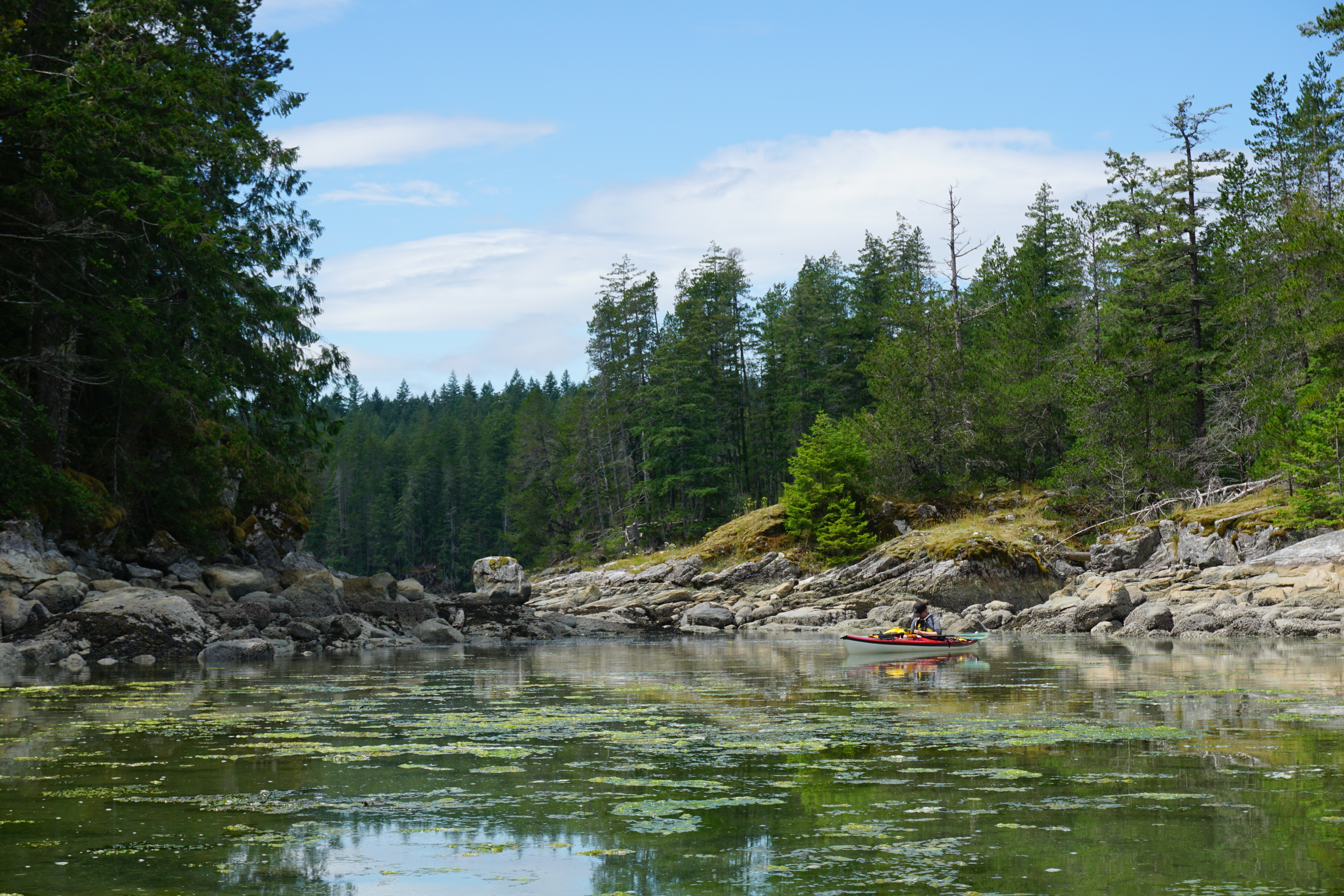
As is usual on one of our trips, I forgot to pack food for one of our meals, so we had an insufficient, cold breakfast of granola and fruit bars before hitting the water. We exited the bay to the west and crossed to the shoreline of Maurelle Island. The wall on the shoreline here is steep and the intertidal life is great at a low tide. We found an abalone, black katy chitons and plethora more intertidal life.

Our ride through the rapids was short-lived and soon we found ourselves in the narrow passage of Hole-in-the-Wall channel. I had never paddled the eastern side of the channel along the Sonora shore, so we crossed over after passing Florence Cove.

The cliffs and scenery on the east side of the channel are gorgeous, however, the feeling of the channel is the same. We did get to paddle under a very large cliff near the northern end of the channel, which was quite beautiful.
Around 1115 we reached the end of the channel and turned north, towards the Yuculta Rapids. We were searching for the namesake of Hole-in-the-Wall channel; a 2m high by 2m wide by 2m deep round hole in a vertical piece of shoreline not far from the entrance. I had visited it once before on an expedition trip up Bute Inlet, and hoped to find it with Lindsay. We battled a surprisingly strong current coming out of Yuculta, and after about 1.5 km of travelling found the distinct hole. To the local First Nations this is a sacred site, known as The Raven’s Chamberpot and sits beside a long abandoned summer seasonal site of the Homalco people.

After admiring the hole, we ripped back down the shore of Sonora in the fast current, crossing the north end of Hole-in-the-Wall. We saw some humpback blows near the abandoned site of Church House, across Calm Channel, but were to far away to see much more than that.
While the shoreline of Maurelle is beautiful, it is rather plain when compared to the rest of the attractions, and the best beach along the shore has been converted to a log dump. After not paddling for months, the monotonous paddling caught up with us and we were searching for a place to take a break.

Near the north of Whiterock Passage, there is the perfect place to stop for a snack and to stretch the legs. A gorgeous little rocky island sits in a bay with a pleasant beach (at high tide) and a nice rock outcrop to sit out on. [Tip: This site is a great place to camp (on the beach at the right tide, on the bluff, or in the forest); however, if you do, note that at low tide, the beach becomes a very long, mud-flat.] Lindsay and I hopped out at a relatively low tide onto a mud covered oyster beach before wandering out to the bluffs to take a break and enjoy the view of Mount Doogie Dowler.
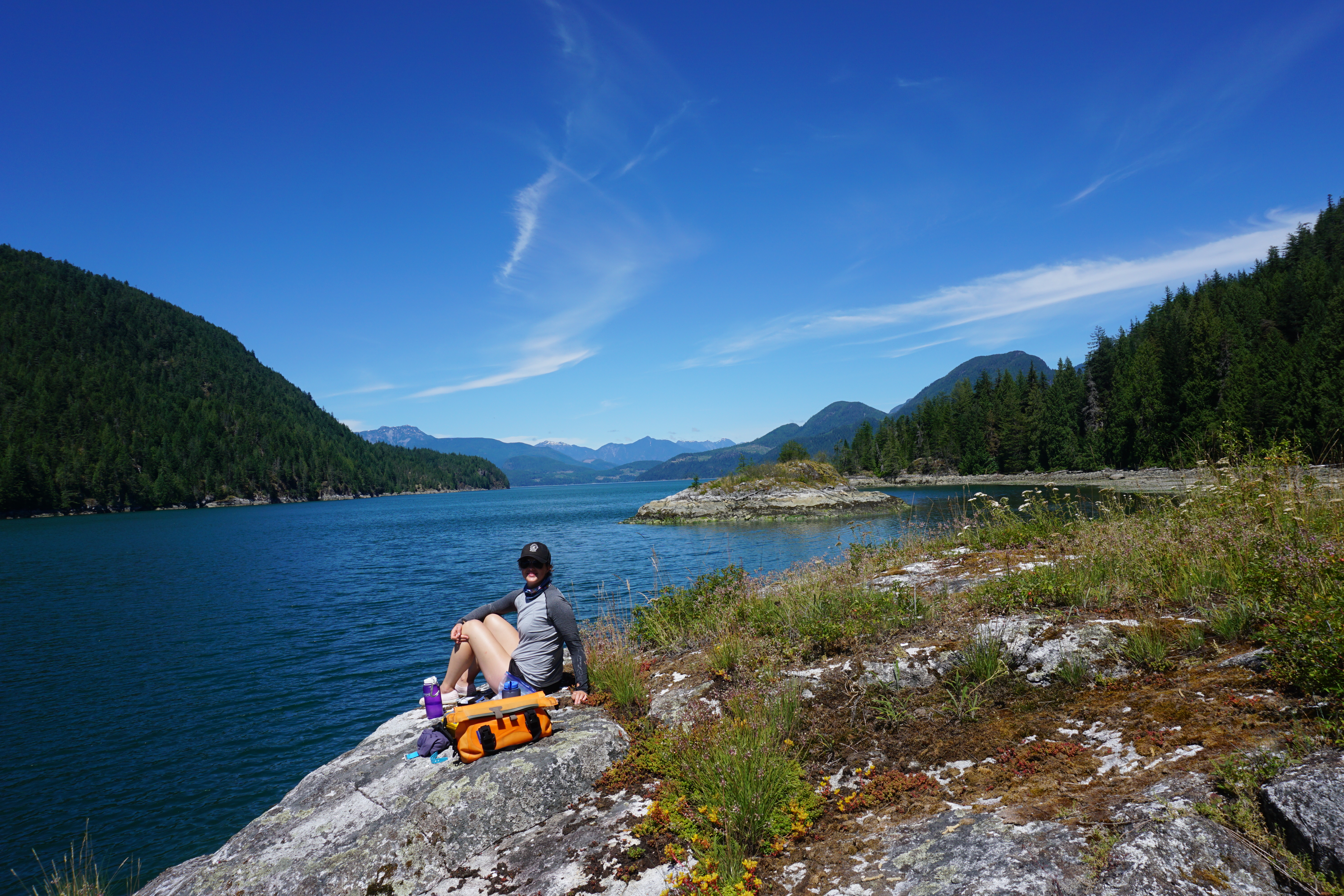
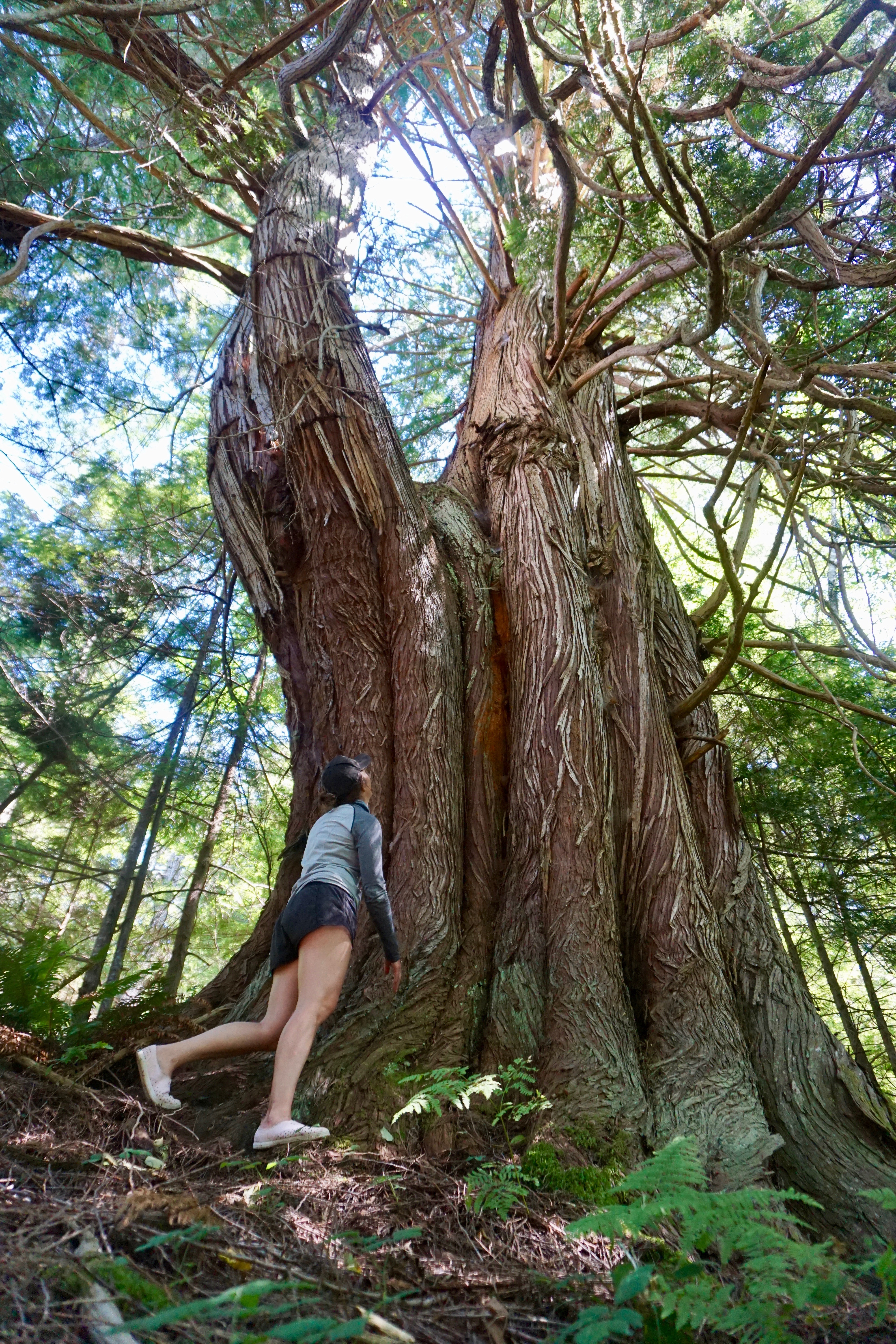
In addition to its nice views, this spot is also home to one of the largest remaining trees in the entire Discovery Islands area! Earlier this year, while guiding a trip, Albi and I ‘discovered’ a massive western red cedar, growing only 20 m from the shore. Despite stopping at this site numerous times before, neither of us had ever seen it from the water. The tree is more then 35 feet around and has a classic candelabra appearance of many old, battered cedars. It is likely more than 600 years old and has seen nearly every single tree surrounding it cut down and hauled off. The best proposed name we have come up with is: the Matriarch Tree.
Stepping out of a coastal rainforest is always a shock to the senses, and after spending time with the Matriarch Tree, being back in the full-sun was nearly unbearable. We hopped back in our boats to finish our loop of Maurelle Island. Leaving our rest stop, we hopped back across Whiterock Passage and stopped to appreciate a First Nations pictograph on the Maurelle shoreline.

From here it was a easy paddle back into the Surge Narrows area. The current was in our favour [Tip: Don’t try to figure out the which way the tide ebbs and floods in Whiterock – it has a mind of its own!] and we scooted through the beautiful kelp forests at the south end of the passage. The tide was still quite low and there was great bird life in the shallow, nutrient rich waters – great blue herons, many types of gulls, pigeon guillemot, and bald eagles all were feasting.

We reached the dock at Surge Narrows around 230pm with enough time to unload and clean the boats up for our 330 pickup. Although one of the shorter trips that Lindsay and I have done in sea kayaks, it was a great trip to kick off the season in a truly beautiful part of the world!
[By the end of the summer, I would end up doing the circumnavigation of Maurelle another six times!]
Please support the Surge Narrows Community Association to help protect this amazing area by making a donation or purchasing a shirt. Check out the website here.

A blast from the past seeing you with our “Captain Calamari” octopus contribution to the old cabin art gallery. Inspiring us to make the trip again in 2024
LikeLike