
A quiet morning in the Plumper Group. Waking up on Banana Slug Islet.
This is not a single trip report, but a series of small trips and photos for trip ideas in the Port McNeill area.

Trips in the Port McNeill area in winter and spring 2021. Routes and campsites in yellow are from 2021, while the other magenta track is from a trip in 2017.
Trips around Malcolm Island, Haddington Island, & Cormorant Island. Day Trips and Short Overnight Adventures.
L and I moved to Hyde Creek in February 2021, just steps from the beach. We were both working from home and stoked to explore the area. In the three months of living there we saw countless orca from the cabin; paddled with the resident sea lions and otters of Haddington Island; and took every opportunity to kayak. We spent many of our afternoons on the water practicing self-rescue skills and assisted rescues. This got much more pleasant when the drysuits arrived, but none the less, Haddington Passage water in mid February still takes your breath away!

Some of the most prominent peaks of the coast are blanketed in snow and dominate the skyline above Malcolm Island: (l to r) Mount Stephens, Corsan Peak, Kul Ta Le Peak.
To read about some of our longer paddles in the area, check out these trip reports:
Wilderness and Wildlife: The area is quite dynamic and feels very exposed at times despite its sheltered location. The wildlife in the area is amazing and incredibly abundant: a small family of Steller sea lions haul out on the east side of Haddington; elk and black bears roam the area freely; ducks frequent the shore front; river and sea otters patrol the beaches; and in the first week a bald eagle snatched a baby blue heron from the beach. Almost every trip in the area is assured healthy intertidal life and the odds of seeing orca – especially in the summer – is considerably higher than most places on the coast.

Bald eagle with juvenile blue heron.

A river otter came by our deck for a nap and a rub…working from home with perks.

Bigg’s orca near Hyde Creek.
Weather & Conditions: During the three months we spent in Hyde Creek it was continually grey. However, I was surprised by the lack of rain that we received – still more than the south coast during the same span, but often the threat of rain was worse than the reality. We did have the occasional “proper” storm though, and many times heard Hurricane Force Wind Warnings on the VHF. It was often much calmer on the inside of Malcolm and we were still able to safely paddle the waters near Haddington Island when Johnstone Strait and Queen Charlotte Strait were raging

Early morning colours over Queen Charlotte Strait.
The wind can certainly build quickly in this area though, and combined with the fast moving waters this can be a challenging area to paddle in unsettled weather. Plan accordingly and remember that your options for paddling will increase again once you reach the shelter of the Broughton Archipelago.

The Haddington Island Steller sea lions.
Around Haddington Island. ~6km.
Haddington Island is located just offshore of Hyde Creek, and sits between Vancouver Island and Malcolm Island. It is about 2 km from the beach in front of our home in Hyde Creek. It was the perfect place for an after work paddle. Haddington Island has a recent interesting history as a stone quarry for andesite, but like most sites on the BC Coast, the First Nation history of the area dates back many thousands of years. Despite its plain appearance, Haddington offers great paddling: the shoreline is cliffy and varied; there is plenty of wildlife in the area; and there are strong currents making for occasionally challenging conditions.

Haddington Stone Quarry 1903/1904. To read more, check out: The Undiscovered Coast.
Over the course of three months in Hyde Creek, L and I paddled around Haddington Island close to thirty times. The shoreline on the south and east sides is cliffy and inaccessible, but offers fun paddling. A rip typically sets up just off the SE corner of the island. There is also great intertidal life in this area at low tides and we occasionally harvested black katy chitons from here.
The north shore of the island is rocky but accessible by kayak. Several bedrock shelves extend into the intertidal and the area is covered in gravel beaches. Be warned if you plan on camping here – a large murder of crows gathers here every night. The west side of the island features a very pleasant sand and gravel beach that is easily accessible at all tide levels. The quarry caretaker property was located here and the upland is flat. Roads crisscross the island, but it is private property and best left unexplored.

Steller sea lion colony hauled out on Haddington Island with shoreline typical of the east side of the island.

The resident Haddington Island sea otter.
Haddington Island makes a fun day trip from a launch somewhere near Port McNeill or Hyde Creek. Orca often frequent the waters around the island and other marine wildlife is abundant. There is interesting shoreline to paddle and a great beach to take a lunch break. You could easily turn this into a full day trip with an extension to either Cormorant or Malcolm Island.
Around Cormorant Island. ~20km.
Cormorant Island is the traditional home of the ‘Namgis First Nation. It is an island located just to the east of Hyde Creek, between Vancouver Island and Malcolm Island. The town of Alert Bay is located on the island. Alert Bay can be accessed by ferry from Port McNeill – you can use this ferry service for your advantage doing short trips around Malcolm and Cormorant Islands.
The town of Alert Bay should not be missed if you are travelling to the area. The U’mista Cultural Centre is a highly educational stop and truly fascinating to explore. It is a highlight for cultural stops in the entire country and should be a visit on many coastal school curriculum. Make sure you do not miss a chance to explore this village if you are in the area – you will regret it!

The First Nations cemetery at Alert Bay (photo from 2017).
L and I have paddled around Cormorant Island and were welcomed to camp there in 2017 when some equipment was damaged and we were waiting for mail. In the three days we spent there we made many friends and were welcomed by an incredibly friendly community. The cultural sites on the island are astounding and there are trails that encircle the entire island, as well as leading to the unique bog ecosystem near the summit.
Currents are strong around the island, particularly on the east side near Gordon Bluff, in Pearse Passage. Use the Weynton Passage current table to time your visit. Great beaches surround the island and make for some great rest stops – make sure you get permission before camping though.
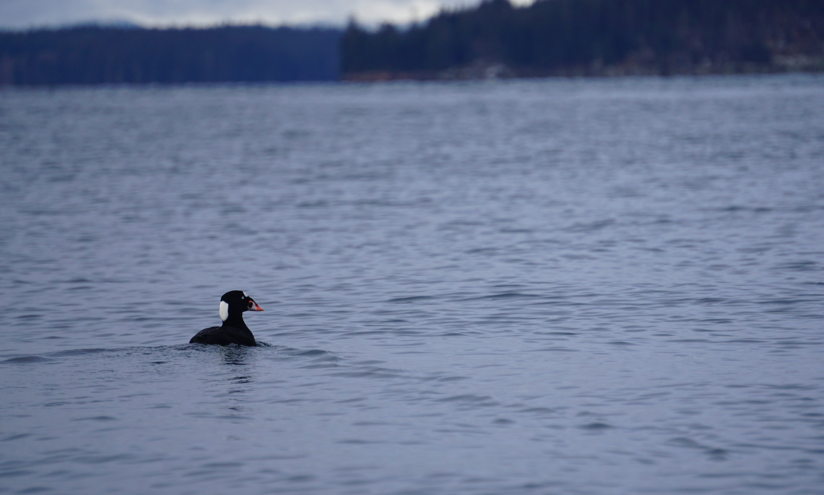
Surf scoter near Haddington Island.
The round trip from our house in Hyde Creek was anywhere from 15-20km, depending on if we wanted to paddle back via Haddington or the Nimpkish. It was a trip we made many times – sometimes just to the pleasant beaches on the NW shoreline. Near Leonard Point there are some gorgeous sand and gravel beaches. The intertidal life is also very heathy in this area.

The beach on the NW point of Cormorant Island.
A loop of Cormorant with a visit to Alert Bay is one of the best day trips in the area and easily your best bang for buck if you only have one day to paddle. Orca often frequent these waters, but the cultural experience alone makes this a fantastic trip.
The Nimpkish Estuary
This is a short trip and can be done from a launch near Hyde Creek or from the launches at Port McNeill or even Alert Bay to make the day a bit longer. I recommend this area if you are pressed for time or conditions are not great elsewhere.

Endangered Trumpeter Swan near the Nimpkish Estuary.
The Nimpkish is one of the great rivers of Vancouver Island and is the longest on the island. It is important for myriad ecosystem services and is a significant cultural site. Today the estuary is often ignored by kayakers as other destinations are more appealing, but it is a great place to paddle. You can easily extend a short day trip here with an exploration of Alert Bay, or launch from Telegraph Cove and make a full day.

Small waterfalls and nice paddling near the entrance to the Nimpkish River.
We left from Hyde Creek on a windy day and stuck to the shoreline to avoid the worst of the waves. We wound our way around Green Island and Flagstaff Island before making our way up the river, just past the bridge. Here, the tide was too low and we could not continue any further. Although there is a dangerous section of canyon further upstream, this would make a great sea kayak descent.
Birds were nesting around the islands and the estuary feels quite healthy. Orca were frequently seen feeding near the mouth of the river during the three months we lived up here. Sea lion are often spotted along this shore.
There are plenty of trails that crisscross the Hyde Creek area (one that even goes to a plane crash) and a few will take you down to the Nimpkish Estuary. These trails are great for running or hiking. L was lucky enough to stumble upon the Nimpkish River petroglyph while out for a run one evening.
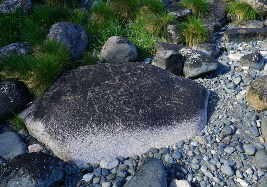
The Nimpkish River petroglyph.
Around Malcolm Island. 65km. 10.5 hours paddling.
Malcolm Island is an island sitting just offshore of Port McNeill in Queen Charlotte Strait. It is about 25km long. Malcolm was formed largely as a result of glacial deposits in the area during the last glacial maximum and its shoreline lacks cliffs, and the beaches are often a pleasant mix of boulders, pebbles, gravel, and sand. The main village of Sointula is accessible by ferry from Alert Bay. Sointula was founded in 1901 as a Finnish utopian socialist society and is a very interesting place to explore. Roads and trails crisscross the island. There is vehicle camping at the orca rubbing beach at Bere Point, a very special spot.

Camping on Banana Slug Islet during a paddle around Malcolm.
I had aborted one attempt to paddle around Malcolm earlier, when the stiff SE I was hoping would help me around turned into a full on gale. I retreated from a camp near Cormorant Island and headed back home. We were running out of time but the conditions finally lined up to try and do a fast paddle around the island. Although I knew I would have enough time in one day to paddle around, I decided to paddle the short distance to the Hansen Island to set me up for an easier following day.
Paddling through the Pearse Group of islands for the first time was fantastic. There is great paddling here and lots of potential for campsites, although I believe many of the sites may be culturally sensitive and inappropriate for camping. I was aiming for the campsite in Leg Cove, but as I approached it, it seemed dark and gloomy. A flat islet about a kilometer to my left looked very appealing, and although the current was flowing strongly against me, I fought hard and earned a great night on a very exposed islet in the Plumper Group with great views across Blackfish Sound.
I began to refer to the island Banana Slug Islet due to the insane amount of banana slugs and enjoyed a wonderful sunset before another great night out kayak camping!

Sunset on Banana Slug Isle with Mount Stephens in the background.
I left early with the sun in the morning and enjoyed some gorgeous light and calm waters while paddling. I took some time to wind through the passage that separates the two large NW islands in the group and then crossed over to Donegal Head. Aside from a bit of moving water in the channel, the ocean was calm. Despite the ideal conditions, a slight wind forecast from the SE had not yet shown up and I was already wishing for some tail wind!

Loading the boat with some gorgeous morning light in Queen Charlotte Strait.
A few kilometers past Donegal Head, I came upon a sea lion carcass being scavenged by turkey vultures and bald eagles. I drifted by and watched this morbid scene unfolding feet from my kayak and reflected on how cool my life was. Then I kept paddling. I stopped to look for some petroglyphs that I knew were in the area, but for the second time on Malcolm Island I could not find any rock art.

Scavenging birds on Malcolm Island. Cool to see the size difference between a juvenile bald eagle and turkey vultures.

Scavenging birds on Malcolm Island.
I made fast work of the calm waters and stopped for a snack at Bere Point. A few campers were lingering about here but nobody was on the beach and I strolled along in solitude. The SE wind finally picked up a bit and I cruised to Malcolm Point in great time. It was still early in the day and I wanted to make good time, but the west side of Malcolm is blessed with great beaches and I slowed my pace a bit.
Unfortunately the SE wind turned to be in my face as I paddled towards Graeme Point, but regardless, I enjoyed the remote shoreline and gravel beaches. I rounded the head and saw the lighthouse at Pulteney Point, where I took a snack break.

Taking a break just beyond the Pulteney Point Lighthouse. This lighthouse is still actively manned and can be accessed from the roads on Malcolm Island, so is often quite busy.
The wind had built considerably and a strong current was flowing out of Broughton Strait. I decided to paddle down the Malcolm shoreline and then ferry over towards Lady Ellen Point. The shoreline here is very interesting and there are short hiking trails in the area that allow you to access the beach from town. I crossed in front of Port McNeill and then paddled along the residential shoreline that I now knew so well. The wind had died once past town and the sun was shining fiercely. It was one of the first truly hot days of spring and I celebrated the circumnavigation with a quick dunk outside our cabin.
This is a great trip that I would suggest three or four days to complete with a launch from Port McNeill. The beaches on the west side of the island are my favourite, with great views and a very remote feeling. There is great camping and hiking scattered all over the island.
The North Island
These are just a few examples of the shorter trip options for sea kayaking on the inside of northern Vancouver Island. Combining these with a road trip or vacation to the Port McNeill area would make for a great itinerary. The North Island is a truly special place with amazing potential, but it suffers from abundant industry. The more we encourage recreation there – sea kayaking, hiking, biking, surfing – the more we can help the local community switch from resource extraction to ecotourism.
Go explore!
