
The Watersprite / Mamquam SW Area seems to be becoming quite popular with improved access and the recent BCMC interest in the area. I have been in there and the Pinecone Area a few times this year and I was planning a longer trip into the area largely to explore the eastern reaches and the alpine area near Bucklin Creek and the beautiful looking Cotard area. Alas the allure of a basecamp at Watersprite Lake was too tempting and I spent three perfect nights camped on the grassy flats at the south-eastern end of the lake. All trips described begin from here.
Day 1: June 25 – Watersprite Tower, Gibson and Martin
The weather was overcast but sweltering, the ceiling stayed at around 2200m the whole day. I persuaded my girlfriend to drive me to the Watersprite trailhead early on Thursday morning. Unfortunately, as is common, we were late, and by the time we reached the turnoff for the Skookum IPP road, she was already late for work. The walk to the trailhead was the worst of the trip. The trail itself is quite pleasant and in great shape – I had only been to the area with snow on the ground.
I reached the lake in 3 hours from the gate and set up camp.
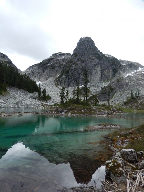 Overcast but still beautiful. Watersprite Lake. I camped on the grass on Overcast but still beautiful. Watersprite Lake. I camped on the grass onthe photos right. |
By this time, overwhelmed by the heat, I had already begun formulating plans to spend all the nights at Watersprite, but I was unsure if I could reach the far peaks in a single day.
I elected on an easy day and climbed Watersprite Tower (WT), then followed the ridge to Gibson and Martin Peaks.
From the lake I headed southeast up a low wide gully directly below WT and gained the first gully on climber’s left, heading northeast. This was quite pleasant and I easily gained the WT-Gibson-Martin ridge. I dropped some gear and skirted left and down beside a prominent “gendarme” (not sure if it truly qualifies). From there I climbed, again keeping left until I could gain the final summit block. Up to that point was perhaps class 4, and the final summit block was class 3 but pretty exposed. I could not stand on the summit, but straddled it instead. I realize this bump should probably not be named, but it is awesome looking from the lake, and was a great view down.
I returned to the ridge the same way and followed it easily to below Gibson. Looking for some more excitement, I eyed a 2-meter wide steep tongue of snow leading up to the summit from the basin below Gibson to the north. I traversed over and climbed steep, surprisingly solid snow to just below the final summit where I chose a scrambly route to the treed top. The views however, were great and I could see east to Bucklin and Cotard peaks, as well as Crawford and far south over the shorter summit of Fender and Washburn.
From the summit, I down-climed the steep western ridge of Gibson enroute to Martin Peak. The scramble along the ridge was quite nice and only one sub-summit must be negotiated. I left a summit register on Martin Peak.
 I left registers on Martin, Dreadnought, Paranoid, Crawford, Fender, and I left registers on Martin, Dreadnought, Paranoid, Crawford, Fender, andWashburn. |
From here I followed the large basin to the north-east back down to the lake and was in swimming immediately. The clouds had finally lifted and the wind had settled and the reflections on the lake were great.
 Watersprite reflections. Watersprite reflections. |
Day 2 – June 26 – Dreadnought,Crawford,Paranoid
The weather was bluebird all day long. I left the lake around 7 with the goal of reaching Bucklin Peak. I also wanted to summit Dreadnought, as I had only climbed it in the winter, and thought I could continue from Dreadnought to Crawford based on the TRIM maps. This proved to be more difficult than anticipated.
I gained the west ridge of Dreadnought by following the forest line immediately from the lake, trying to seek shade. I cut across the bowl below Dreadnought on the south and gained the western summit easily. There are three summits on Dreadnought, all of which seem to be about equal in height, but the SE summit is currently the highest as it still has a snow pack. I replaced and dried out the previous entries in the summit register on the W summit, then climbed the other summits. The NE summit was the most exposed and a gully slicing the eastern face had to be crossed.
Seeing no easy way down the SE ridge, I decided to down-climb the east face. This was not much fun. I down-climbed low 5th class rock with tree protection, then crossed the gully to the south and continued down steep rock till I gained a snow tongue that took me down to the west ridge of Crawford. The descent took 30 min and I do not recommend it.
 The east face of Dreadnought. I crossed the gully from right to left just The east face of Dreadnought. I crossed the gully from right to left justbelow the upper snow and then followed the ridges down to the snow tongue connecting to the col. |
This ridge was slow travel with many bumps and cliffs, but I gained the col before Crawford where a small alpine lake remained frozen. I rested there in the shade and then pushed on to Crawford, climbing easy snow and solid rock to the summit.
 Multiple peaks of the Cotard area. Cotard peak is to the left. Multiple peaks of the Cotard area. Cotard peak is to the left.Taken from near the summit of Crawford. |
A great cairn was already there, but I left another register and spent some time on the summit. The views across the Pitt River were splendid: from Mt Pitt, Snowcap, Misty, Stave down to the regular Golden Ears summits and NS peaks.
 Mt. Pitt from Crawford Peak Mt. Pitt from Crawford Peak |
From here I finally admitted Bucklin would be too far for me today, but had already formulated a plan to return.
 The rugged Bucklin Peak. The rugged Bucklin Peak. |
From the summit of Crawford, I dropped about 300m to the NE and then gained the SE ridge of Paranoid Peak via a loose snow and scree gully.
 Crawford Peak from the north (the high snow capped peak). All the sub peaks Crawford Peak from the north (the high snow capped peak). All the sub peakscan be avoided on the ascent. |
The ridge was gentle, and the final scramble to the summit was up beautiful heather and wildflower ledges.
 Paranoid Peak from the north side of Crawford, near the summit – the peak Paranoid Peak from the north side of Crawford, near the summit – the peakis dwarfed by Mamquam |
This summit offered great views of Bucklin valley and the south face of Mamquam. A cairn was pre-existing, but I left my last register – the one intended for Bucklin.
 Bucklin Peak and valley from Paranoid Peak Bucklin Peak and valley from Paranoid Peak |
The return was uneventful and hot.
 Looking up the soft snow slog to Crawford Peak from the col between it Looking up the soft snow slog to Crawford Peak from the col between itand Paranoid Peak on my return to the lake. My descent tracks can be seen to right of the summit. |
I dropped off the west ridge of Crawford and gained the col between Dreadnought and the Watersprite Lake summits and then reached the lake easily. The avalanche debris in this bowl is awesome and the boulders are massive!
Day 3 – June 27 – Epiphone,Fender,
Another brilliant day. I decided to finish all the “guitar-themed” summits today. Another hiker had arrived at the lake in the night – Dan – and he set off for Martin and Gibson peaks, but I would not see him again all day (although apparently he saw me plenty). I climbed the same low angle gully below WT, this time continuing to the ridge and heading east to Epiphone Peak. This peak is merely a bump, and at least according to my GPS, is lower than the broad summit to the SE by 1m. (Editors Note: the south peak of Epiphone.
I followed this SE trending ridge to the base of Fender Peak.
 The final summit block of Fender Peak from the gentle ridge to the north. The final summit block of Fender Peak from the gentle ridge to the north.I took the second of two prominent gullies bisecting the north face at the notch in centre-left of photo. It was class 3. |
From there I followed the second prominent gully bisecting the northern face, which was stiff class 3, to the summit ridge.
 The south slopes of Gibson Peak above Martin Lake from Fender Peak. The south slopes of Gibson Peak above Martin Lake from Fender Peak. |
A short walk and I was on the summit – views of Martin Lake, Pinecone Peaks, and Cotard area were great!
 Bucklin appears again from Fender Peak. Bucklin appears again from Fender Peak. |
Washburn also looked like fun.
 Washburn Peak, from Fender. I avoided the rock band on the right and used Washburn Peak, from Fender. I avoided the rock band on the right and usedthe gully angling from centre of the photo to the right to gain the gentle ridge |
I dropped off the west side of Fender and followed the ridge to Washburn Peak. Skirting south around the first prominent rock-band, I then followed an easy gully to the summit ridge. There are actually two summits – the eastern most being the shortest at 1830m with the western summit at 1835m. The summits are separated by a narrow gully which can be easily negotiated on the south. I built a cairn on this summit and left another register. Great views to the Pinecone Peaks across Crawford valley!
 Pinecone Peak north face and Seed Peak in the background to the right, Pinecone Peak north face and Seed Peak in the background to the right,from Washburn. |
I find it hard to believe no-one has climbed this summit – although short, it is prominent and offers great views, and access in the past would have been much simpler with logging roads terminating quite high on the southern flanks of both Fender and Washburn.
I dropped down to “Upper Martin Lake” to grab some water and then traversed the bowls south of Gibson and Martin peaks staying high and crossing multiple ribs off the Epiphone- Fender ridge. Returned to the lake, where a few hours later, Dan – who had followed almost the same route as I, just behind me a bit, offered me some beer and conversation for the first time in days.
On the final day, we hiked down together, making quick work of the dry trail. Saw two people heading up for the day and a Red-breasted Sapsucker. No wildlife the whole trip, but a lot of evidence of goats. This is a great sub-alpine area with easy access offering views into the more glaciated regions close to Vancouver. Most of the summits around the lake are easy ridge rambles and the water should be warm come September with a lot of the snow gone and the water level low this year!
 Living the good life at Watersprite. The perfect campsite, with the perfect Living the good life at Watersprite. The perfect campsite, with the perfectreading/sitting/eating/lounging rock. |
